Difference between revisions of "2015-06-05 52 13"
imported>GeorgDerReisende (create page) |
imported>GeorgDerReisende (expedition report for Berlin-Müggelheim) |
||
| Line 1: | Line 1: | ||
| − | |||
| − | |||
| − | |||
| − | |||
| − | |||
| − | |||
| − | |||
| − | |||
| − | |||
| − | |||
{{meetup graticule | {{meetup graticule | ||
| lat=52 | | lat=52 | ||
| Line 18: | Line 8: | ||
__NOTOC__ | __NOTOC__ | ||
== Location == | == Location == | ||
| − | + | ||
| + | The hash lay between the forest and the lake Seddinsee in Berlin-Müggelheim. | ||
== Participants == | == Participants == | ||
| − | + | ||
| − | + | [[User:GeorgDerReisende|GeorgDerReisende]] | |
== Plans == | == Plans == | ||
| − | + | ||
| + | I was on a journey to a wedding nearby, so I tried to make another hash. | ||
== Expedition == | == Expedition == | ||
| − | |||
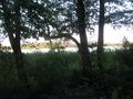
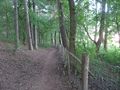
| − | + | After visiting [[2015-06-05 52 9]], I hitchhiked from Garbsen to Berlin. I took some public transport and arrived at Berlin-Müggelheim. I walked into the direction of the hash and arrived at the lake. To the right there was a little beach, but to the left and to the hash, there was a fence between the path and the lake. I took this path and at the shortest distance I found 28 meters between me and the hash. The hash lay within the reed. | |
| − | |||
== Photos == | == Photos == | ||
| Line 38: | Line 28: | ||
--> | --> | ||
<gallery perrow="5"> | <gallery perrow="5"> | ||
| + | 2015-06-05 52 13 GeorgDerReisende 7979.jpg | arriving at Berlin-Müggelheim | ||
| + | 2015-06-05 52 13 GeorgDerReisende 7985.jpg | walking into the forest | ||
| + | 2015-06-05 52 13 GeorgDerReisende 8006.jpg | small beach to the right | ||
| + | 2015-06-05 52 13 GeorgDerReisende 8007.jpg | fence at the path's side to the left | ||
| + | 2015-06-05 52 13 GeorgDerReisende 8010.jpg | too far away | ||
| + | 2015-06-05 52 13 GeorgDerReisende 8011.jpg | 28 meters | ||
| + | 2015-06-05 52 13 GeorgDerReisende 8012.jpg | view to the hash | ||
| + | 2015-06-05 52 13 GeorgDerReisende 8013.jpg | again the fence | ||
| + | 2015-06-05 52 13 GeorgDerReisende 8014.jpg | no luck here | ||
</gallery> | </gallery> | ||
| − | + | [[Category:Expeditions]] | |
| − | |||
| − | |||
| − | |||
| − | |||
| − | |||
| − | |||
| − | |||
| − | |||
| − | |||
| − | |||
| − | |||
| − | |||
| − | |||
| − | |||
| − | |||
| − | |||
| − | |||
[[Category:Expeditions with photos]] | [[Category:Expeditions with photos]] | ||
| − | |||
| − | |||
| − | |||
| − | |||
| − | |||
| − | |||
| + | [[Category:Coordinates not reached]] | ||
| − | |||
| − | |||
| − | |||
| − | |||
| − | |||
| − | |||
| − | |||
[[Category:Not reached - No public access]] | [[Category:Not reached - No public access]] | ||
| − | |||
| − | |||
| − | |||
| − | |||
| − | |||
| − | |||
| − | |||
| − | |||
Revision as of 07:49, 10 June 2015
| Fri 5 Jun 2015 in 52,13: 52.3938772, 13.6864041 geohashing.info google osm bing/os kml crox |
Location
The hash lay between the forest and the lake Seddinsee in Berlin-Müggelheim.
Participants
Plans
I was on a journey to a wedding nearby, so I tried to make another hash.
Expedition
After visiting 2015-06-05 52 9, I hitchhiked from Garbsen to Berlin. I took some public transport and arrived at Berlin-Müggelheim. I walked into the direction of the hash and arrived at the lake. To the right there was a little beach, but to the left and to the hash, there was a fence between the path and the lake. I took this path and at the shortest distance I found 28 meters between me and the hash. The hash lay within the reed.
Photos
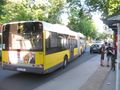
arriving at Berlin-Müggelheim
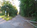
walking into the forest
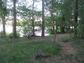
small beach to the right
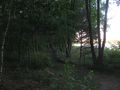
fence at the path's side to the left

too far away

28 meters
view to the hash
again the fence
no luck here


