Difference between revisions of "2015-06-12 48 9"
imported>Klaus (documented everything) |
imported>Klaus (fixed image) |
||
| Line 1: | Line 1: | ||
| + | [[Image:{{{image|2015-06-12 48 9 Hashorama.jpg}}}|thumb|left]] | ||
| − | |||
| − | |||
| − | |||
| − | |||
| − | |||
| − | |||
| − | |||
| − | |||
| − | |||
{{meetup graticule | {{meetup graticule | ||
| lat=48 | | lat=48 | ||
| Line 15: | Line 7: | ||
}} | }} | ||
| − | |||
__NOTOC__ | __NOTOC__ | ||
== Location == | == Location == | ||
Revision as of 17:13, 12 June 2015

| Fri 12 Jun 2015 in 48,9: 48.6096998, 9.0112412 geohashing.info google osm bing/os kml crox |
Location
very near to the area of the golf club "Schönbuch"
Participants
Plans
Klaus will try his second geohash by cycling from Tübingen. I'll try to start after work around 16:15 and should be there around 17:15-17:30.
This geohash seems to be a perfect candidate for the golf achievement, but unfortunately I don't possess any golf equipment :(
Expedition
I started at around 16:00, although it seemed like a thunderstorm was upcoming soon. Because of the dark clouds I drove the bicycle like crazy all the way through the nature reserve "Schönbuch" up the hill to the geohash.
The last kilometer there were golf courses right and left of my road and there were quite a lot people playing. Maybe I should have asked one if I could borrow some golf equipment so I would get the golf achievement? Not sure what the answer would have been :)
When I arrived at the geohash around 17:00 and it started to trickle. Luckily, it stopped soon and it didn't start to rain. Because the way home was going downhill and I was driving fast, I missed one section and made a little detour.
All in all I drove around 36km with my bicycle.
Tracklog
see photo below
Photos
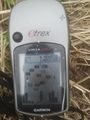
Proof
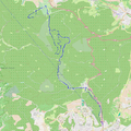
Tracklog
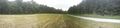
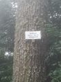
Hashorama
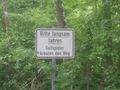
Please drive slowly: Golf players crossing!
WTF is a "schnaps oak"?


Achievements
Klaus earned the Land geohash achievement
|
Klaus earned the Bicycle geohash achievement
|