Difference between revisions of "2015-06-23 43 -116"
From Geohashing
imported>Eldin (mark as planning page) |
imported>Eldin (update after expedition) |
||
| Line 28: | Line 28: | ||
== Expedition == | == Expedition == | ||
| − | + | We got started about 40 minutes late, but beyond that, everything went quite smoothly. We parked by the road near the hashpoint at about 9:50pm, spent a few minutes between walking to the hash and trying to get a solid GPS lock, took some pictures, and then headed out to grab some food before returning home. | |
| − | |||
| Line 36: | Line 35: | ||
Image:2012-##-## ## ## Alpha.jpg | Witty Comment | Image:2012-##-## ## ## Alpha.jpg | Witty Comment | ||
--> | --> | ||
| − | <gallery | + | <gallery> |
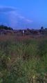
| + | File:2015-06-23 43 -116 geohashers.jpg | Eldin and Borneo at the hashpoint. | ||
| + | File:2015-06-23 43 -116 point.jpg | The hashpoint is about 3ft towards me from the fencepost with the poster. | ||
| + | File:2015-06-23 43 -116 poster.jpg | Closer shot of the poster left at the site. | ||
| + | File:2015-06-23 43 -116 sunset.jpg | The sunset, as viewed at the hashpoint. | ||
| + | File:2015-06-23 43 -116 proof.png | Proof that we were in the right place. | ||
</gallery> | </gallery> | ||
== Achievements == | == Achievements == | ||
{{#vardefine:ribbonwidth|800px}} | {{#vardefine:ribbonwidth|800px}} | ||
| − | + | {{land geohash | |
| − | + | | latitude = 43 | |
| − | + | | longitude = -116 | |
| − | + | | date = 2015-06-23 | |
| − | + | | name = [[User:Eldin|Eldin]] & Borneo | |
| − | + | }} | |
| − | |||
| − | [[ | ||
| − | |||
| − | |||
[[Category:Expeditions]] | [[Category:Expeditions]] | ||
| − | |||
[[Category:Expeditions with photos]] | [[Category:Expeditions with photos]] | ||
| − | |||
| − | |||
| − | |||
| − | |||
| − | |||
[[Category:Coordinates reached]] | [[Category:Coordinates reached]] | ||
| − | |||
| − | |||
| − | |||
| − | |||
| − | |||
| − | |||
| − | |||
| − | |||
| − | |||
| − | |||
| − | |||
| − | |||
| − | |||
| − | |||
| − | |||
| − | |||
| − | |||
| − | |||
Revision as of 17:27, 24 June 2015
| Tue 23 Jun 2015 in 43,-116: 43.9234485, -116.8941566 geohashing.info google osm bing/os kml crox |
Location
At the intersection of Elmore Rd. and Fairview Ave, south of Fruitland, ID.
Participants
Eldin & Borneo
Plans
I expect to leave home to head towards the hash around 8pm, which should put us at the hashpoint around 9.
Expedition
We got started about 40 minutes late, but beyond that, everything went quite smoothly. We parked by the road near the hashpoint at about 9:50pm, spent a few minutes between walking to the hash and trying to get a solid GPS lock, took some pictures, and then headed out to grab some food before returning home.
Photos

Eldin and Borneo at the hashpoint.
The hashpoint is about 3ft towards me from the fencepost with the poster.
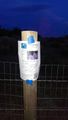
Closer shot of the poster left at the site.
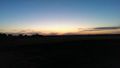
The sunset, as viewed at the hashpoint.
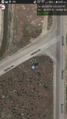
Proof that we were in the right place.


Achievements
Eldin & Borneo earned the Land geohash achievement
|