Difference between revisions of "2015-07-17 52 1"
From Geohashing
imported>Sourcerer m ([live] Arrived.) |
imported>Sourcerer m ([live picture] Proof. [http://www.openstreetmap.org/?lat=52.51237929&lon=1.04334712&zoom=16&layers=B000FTF @52.5124,1.0433]) |
||
| Line 26: | Line 26: | ||
<gallery perrow="5"> | <gallery perrow="5"> | ||
| + | |||
| + | Image:2015-07-17_52_1_Sourcerer_1437167790039.jpg | Proof. [http://www.openstreetmap.org/?lat=52.51237929&lon=1.04334712&zoom=16&layers=B000FTF @52.5124,1.0433] | ||
</gallery> | </gallery> | ||
Revision as of 21:18, 17 July 2015
| Fri 17 Jul 2015 in 52,1: 52.5124496, 1.0433368 geohashing.info google osm bing/os kml crox |
Location
In a field east of Attleborough, Norfolk, UK.
Participants
Plans
Expedition
This hashpoint was 990 metres from my expedition to 2015-05-03 52 1.
- Arrived. -- Sourcerer (talk) @52.5124,1.0433 22:17, 17 July 2015 (GMT+01:00)
Photos
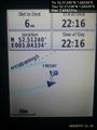
Proof. @52.5124,1.0433

Achievements
Sourcerer earned the OpenStreetMap achievement
|
Expeditions and Plans
| 2015-07-17 | ||
|---|---|---|
| Pforzheim, Germany | RecentlyChanged | Near a small pass in the black forest. |
| Stuttgart, Germany | Ekorren | No trespassing. Walked there and took a look. Report might be done before 2... |
| Nürnberg, Germany | Schnatterfleck | The watering pipeline in a field of celery near Kraftshof. |
| Norwich, United Kingdom | Sourcerer | In a field east of Attleborough, Norfolk, UK. |
| Warszawa East, Poland | Ziemek, Ziemba, Norill | Middle of the field in Serock. |
Sourcerer's Expedition Links
2015-07-14 52 1 - 2015-07-17 52 1 - 2015-07-19 52 1 - KML file download of Sourcerer's expeditions for use with Google Earth.