Difference between revisions of "2015-07-17 49 11"
imported>Sourcerer m (→Corrected Category) |
imported>FippeBot m (Location) |
||
| Line 82: | Line 82: | ||
[[Category:Expeditions with photos]] | [[Category:Expeditions with photos]] | ||
[[Category:Coordinates reached]] | [[Category:Coordinates reached]] | ||
| + | {{location|DE|BY|N}} | ||
Latest revision as of 04:23, 15 August 2019
| Fri 17 Jul 2015 in 49,11: 49.5124496, 11.0433368 geohashing.info google osm bing/os kml crox |
Location
The watering pipeline in a field of celery near Kraftshof.
Participants
Plans
Expedition
Friday and some overtime to spend... And a hashpoint in reach! :-) So I took a small detour with my bike through the Knoblauchsland ("garlic land" - ridiculous but accurate 500 year old name). First I went through Nurembergs northern city and drove along the airport runway. Then there were just plants. And lettuce. And vegetables. Some flowers. More plants. Going on for kilometres without and. A very special landscape. Oh, and there are the various watering devices. It was 35°C and the sun was burning. But unfortunately the sprinkler right at the hashpoint was turned off. Damn. Would have been perfect. Nonetheless - a very nice and refreshing (I got my dosage of sprinkler water on the way back :-) ) little adventure.
Tracklog
Photos
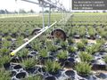
Massively parallel automated plant pot watering @49.5014,11.0523
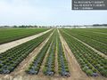
Enough little patio greenery for the better part of southern Germany @49.5032,11.0508
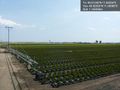
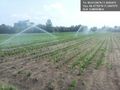
Another watering device. In the background you can make out the tower of Nuremberg's airport. @49.5032,11.0506
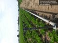
This watering device is located right at the hashpoint. @49.5125,11.0433
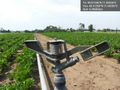
Interesting construction... @49.5125,11.0433
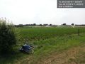
Bike near hashpoint. Artificial rain in the background. @49.5125,11.0433
Finally getting really wet :-) @49.4775,11.0447
Small rainbow (lower left) and asparagus field (also left) @49.4776,11.0446


