Difference between revisions of "2015-07-27 49 8"
imported>Tads (→Plans) |
imported>Tads |
||
| Line 1: | Line 1: | ||
| − | |||
| − | |||
| − | |||
| − | |||
| − | |||
| − | |||
| − | |||
| − | |||
| − | |||
| − | |||
{{meetup graticule | {{meetup graticule | ||
| lat=49 | | lat=49 | ||
| Line 15: | Line 5: | ||
}} | }} | ||
| − | |||
__NOTOC__ | __NOTOC__ | ||
| Line 25: | Line 14: | ||
== Plans == | == Plans == | ||
| − | |||
[[User:tads|tads]] considers going to the hashpoint by train and bike on Monday afternoon. He might additionally visit [[wikipedia:Otzberg_Castle|Otzberg Castle]] which is close by. | [[User:tads|tads]] considers going to the hashpoint by train and bike on Monday afternoon. He might additionally visit [[wikipedia:Otzberg_Castle|Otzberg Castle]] which is close by. | ||
| Line 53: | Line 41: | ||
== Achievements == | == Achievements == | ||
{{#vardefine:ribbonwidth|800px}} | {{#vardefine:ribbonwidth|800px}} | ||
| − | |||
| − | |||
[[Category:Expeditions]] | [[Category:Expeditions]] | ||
[[Category:Expeditions with photos]] | [[Category:Expeditions with photos]] | ||
[[Category:Coordinates reached]] | [[Category:Coordinates reached]] | ||
Revision as of 15:02, 4 September 2015
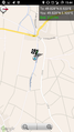
| Mon 27 Jul 2015 in 49,8: 49.8278308, 8.9195462 geohashing.info google osm bing/os kml crox |
Location
The hashpoint is located on a field in Otzberg-Zipfen.
Participants
Plans
tads considers going to the hashpoint by train and bike on Monday afternoon. He might additionally visit Otzberg Castle which is close by.
Expedition
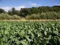
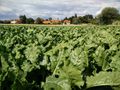
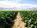
I first cycled to Darmstadt-Lichtwiese station, where I got on the train to Otzberg-Lengfeld. From there it was a quick ride to Otzberg-Zipfen. There it started to rain a bit. In Zipfen I first took the wrong road out of town which brought me further from the hash, so I had to go back. A smaller path then lead me towards cabbage(?) fields. The rain had stopped by now.
I got off my bike and tried to find a way to the hashpoint. The hashpoint was located a few meters inside one of the fields. I tried to be as careful as possible and not to step on any plants. At the spot I took photos and the GPS proof and then quickly (while still careful) went out of the field again.
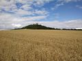
Next, I continued my way to Veste Otzberg which was nicely visible on the close-by hill already. The ascend up the Hill to Otzberg-Hering was quite steep! At the castle I had a rest and enjoyed the stunning view on the surrounding area.
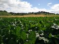
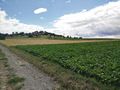
The way back went along plenty of fields, a scenery that I liked very much. The track went through Nieder-Klingen and Ueberau to Reinheim. From there I took the train back to Darmstadt.
Photos
GPS proof
View to the east
View to the north
View to the south
View to the west
The Veste Otzberg is very close
Looking back to the Veste Otzberg
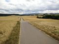
Crop fields on the way back
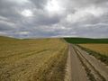
More fields on the way back


