Difference between revisions of "2015-08-28 48 9"
From Geohashing
imported>Klaus (plans... gotta sleep now, only six hours left!) |
imported>Klaus (write expedition) |
||
| Line 1: | Line 1: | ||
| − | + | [[Image:{{{image|2015-08-28_48_9_marker.jpg}}}|thumb|left]] | |
| − | |||
| − | |||
| − | |||
| − | |||
| − | |||
| − | |||
{{meetup graticule | {{meetup graticule | ||
| lat=48 | | lat=48 | ||
| Line 28: | Line 22: | ||
== Expedition == | == Expedition == | ||
| − | + | Ok, I overslept and left "only" at 7:00am. Some quite steep hills and some morning sport later, I arrived shortly after 8:00. The way back was much easier (downhill) and took me less than 45 minutes. | |
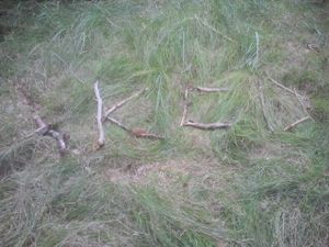
| + | Was easy to reach, and I left my first (biodegradable) marker :) | ||
| + | Can't write more for now, as I still have to go to work, and it's already 9:06 now :) | ||
== Tracklog == | == Tracklog == | ||
| − | + | Ain't nobody got time for that! | |
== Photos == | == Photos == | ||
| − | |||
| − | |||
| − | |||
<gallery perrow="5"> | <gallery perrow="5"> | ||
| + | Image:2015-08-28_48_9_before_hash.jpg | Let's go bushwhacking (was easy this time) | ||
| + | Image:2015-08-28_48_9_proof.jpg | Proof | ||
| + | Image:2015-08-28_48_9_marker.jpg | My first marker ever! | ||
| + | Image:2015-08-28_48_9_marker2.jpg | Spot it?! | ||
</gallery> | </gallery> | ||
== Achievements == | == Achievements == | ||
{{#vardefine:ribbonwidth|800px}} | {{#vardefine:ribbonwidth|800px}} | ||
| − | |||
| − | + | {{land geohash | |
| − | + | | latitude = 48 | |
| − | + | | longitude = 9 | |
| − | + | | date = 2015-08-28 | |
| − | + | | name = [[User:Klaus|Klaus]] | |
| − | + | }} | |
| − | [[ | ||
| − | |||
| − | + | {{bicycle geohash | |
| + | | latitude = 48 | ||
| + | | longitude = 9 | ||
| + | | date = 2015-08-28 | ||
| + | | name = [[User:Klaus|Klaus]] | ||
| + | | distance = 18km | ||
| + | | bothways = true | ||
| + | }} | ||
| − | |||
[[Category:Expeditions]] | [[Category:Expeditions]] | ||
| − | |||
[[Category:Expeditions with photos]] | [[Category:Expeditions with photos]] | ||
| − | |||
| − | |||
| − | |||
| − | |||
| − | |||
[[Category:Coordinates reached]] | [[Category:Coordinates reached]] | ||
| − | |||
| − | |||
| − | |||
| − | |||
| − | |||
| − | |||
| − | |||
| − | |||
| − | |||
| − | |||
| − | |||
| − | |||
| − | |||
| − | |||
| − | |||
| − | |||
| − | |||
| − | |||
Revision as of 07:07, 28 August 2015
| Fri 28 Aug 2015 in 48,9: 48.5759198, 9.0423219 geohashing.info google osm bing/os kml crox |
Location
northwest of Bebenhausen in Schönbuch
Participants
Plans
too close from Tübingen to let go... Unfortunately, I have barely time tomorrow, but if I manage to wake up early (6:00am) , I might be able to do it by bicycle before work, ETA 7:00am at the hashpoint!
Expedition
Ok, I overslept and left "only" at 7:00am. Some quite steep hills and some morning sport later, I arrived shortly after 8:00. The way back was much easier (downhill) and took me less than 45 minutes. Was easy to reach, and I left my first (biodegradable) marker :) Can't write more for now, as I still have to go to work, and it's already 9:06 now :)
Tracklog
Ain't nobody got time for that!
Photos
Achievements
Klaus earned the Land geohash achievement
|
Klaus earned the Bicycle geohash achievement
|


