Difference between revisions of "2015-09-04 50 -1"
From Geohashing
imported>Zamzara (Placeholder) |
imported>Zamzara |
||
| Line 1: | Line 1: | ||
| − | [ | + | {{meetup graticule |
| + | | lat=50 | ||
| + | | lon=-1 | ||
| + | | date=2015-09-04 | ||
| + | }} | ||
| + | |||
| + | __NOTOC__ | ||
| + | == Location == | ||
| + | The geohash was at the edge of a field near Newport, Isle of Wight. It was reached by [[User:Zamzara|Zamzara]] who followed a footpath from the junction of Halberry Lane with Fairlee Road. The field was accessible at the top of an embankment on the eastern side of the footpath. | ||
| + | |||
| + | == Photos == | ||
| + | <gallery perrow="5"> | ||
| + | Image:WP_20150904_003.jpg | Marker created on the morning | ||
| + | Image:WP_20150904_004.jpg | The location | ||
| + | Image:WP_20150904_005.jpg | Geohashdroid | ||
| + | |||
| + | </gallery> | ||
| + | |||
| + | [[Category:Expeditions]] | ||
| + | [[Category:Expeditions with photos]] | ||
| + | [[Category:Coordinates reached]] | ||
Revision as of 17:57, 4 September 2015
| Fri 4 Sep 2015 in 50,-1: 50.7091185, -1.2807973 geohashing.info google osm bing/os kml crox |
Location
The geohash was at the edge of a field near Newport, Isle of Wight. It was reached by Zamzara who followed a footpath from the junction of Halberry Lane with Fairlee Road. The field was accessible at the top of an embankment on the eastern side of the footpath.
Photos
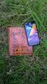
Marker created on the morning

The location
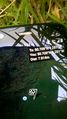
Geohashdroid


