Difference between revisions of "2015-09-05 49 8"
From Geohashing
imported>Tads (→Expedition) |
imported>Tads |
||
| Line 1: | Line 1: | ||
| − | |||
| − | |||
| − | |||
| − | |||
| − | |||
| − | |||
| − | |||
| − | |||
| − | |||
| − | |||
{{meetup graticule | {{meetup graticule | ||
| lat=49 | | lat=49 | ||
| Line 42: | Line 32: | ||
</gallery> | </gallery> | ||
| − | |||
[[Category:Expeditions]] | [[Category:Expeditions]] | ||
[[Category:Expeditions with photos]] | [[Category:Expeditions with photos]] | ||
[[Category:Coordinates reached]] | [[Category:Coordinates reached]] | ||
Revision as of 14:57, 7 September 2015
| Sat 5 Sep 2015 in 49,8: 49.8501532, 8.6747570 geohashing.info google osm bing/os kml crox |
Location
In the wood just outside of Darmstadt.
Participants
Plans
Tads will go there in the morning or around noon.
Expedition
This expedition was quickly done. I cycled only 3 km to the border of Darmstadt (at Böllenfalltor). There I left my bike next to the road and continued on foot into the forest where I had to perform a little hash dance as the GPS coordinates kept changing from time to time. In the vicinity of the hashpoint I left some chalk marks on the trees and took photos. Finally, I went back to get my bike and do the grocery shopping for the weekend..
Photos
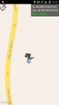
GPS proof
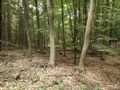
Chalk marks
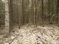
View to the north
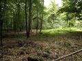
View to the south
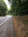
The spot was very close to this road.


