Difference between revisions of "2015-09-13 52 0"
From Geohashing
imported>Sourcerer m ([live picture] Proof. [http://www.openstreetmap.org/?lat=52.14836061&lon=.96277356&zoom=16&layers=B000FTF @52.1484,.9628]) |
imported>Sourcerer m ([live] Arrived) |
||
| Line 22: | Line 22: | ||
| + | |||
| + | *Arrived -- [[User:Sourcerer|Sourcerer]] ([[User talk:Sourcerer|talk]]) [http://www.openstreetmap.org/?lat=52.14808166&lon=.96289158&zoom=16&layers=B000FTF @52.1481,.9629] 00:03, 13 September 2015 (GMT+01:00) | ||
== Photos == | == Photos == | ||
Revision as of 23:03, 12 September 2015
| Sun 13 Sep 2015 in 52,0: 52.1483814, 0.9624462 geohashing.info google osm bing/os kml crox |
Location
A front drive at Battisford Tye, Suffolk, UK - hindering.bronzer.printout.
Participants
Plans
Expedition two of two spanning midnight - 2015-09-12 52 0 - 2015-09-13 52 0 - ETA 00:00.
Expedition
- Arrived -- Sourcerer (talk) @52.1481,.9629 00:03, 13 September 2015 (GMT+01:00)
Photos
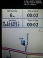
Proof. @52.1484,.9628

Achievements
Sourcerer earned the OpenStreetMap achievement
|
Expeditions and Plans
| 2015-09-13 | ||
|---|---|---|
| Colac, Australia | Benjamin Kaiser | Farm near Inverleigh. |
| Kaiserslautern, Germany | strongblackcoffee | On the edge of Münchweiler am Klingbach |
| Cambridge, United Kingdom | Sourcerer | A front drive at Battisford Tye, Suffolk, UK - hindering.bronzer.printout. |
Sourcerer's Expedition Links
2015-09-12 52 0 - 2015-09-13 52 0 - 2015-09-14 52 1 - KML file download of Sourcerer's expeditions for use with Google Earth.