Difference between revisions of "2015-09-16 41 -88"
From Geohashing
imported>Haberdasher (→Photos) |
imported>Haberdasher m (→Photos) |
||
| Line 25: | Line 25: | ||
Image:2015-09-16_41_-88GPS.JPG | Hashpoint reached! | Image:2015-09-16_41_-88GPS.JPG | Hashpoint reached! | ||
Image:2015-09-16_41_-88Hashyard.JPG | The hashyard | Image:2015-09-16_41_-88Hashyard.JPG | The hashyard | ||
| − | Image:2015-09-16_41_- | + | Image:2015-09-16_41_-88StupidGrin.JPG | Obligatory Stupid Grin |
Image:2015-09-16_41_-88HashArea.JPG | The area of the hash | Image:2015-09-16_41_-88HashArea.JPG | The area of the hash | ||
</gallery> | </gallery> | ||
Revision as of 00:36, 17 September 2015
| Wed 16 Sep 2015 in 41,-88: 41.8386745, -88.0507337 geohashing.info google osm bing/os kml crox |
Location
A driveway in a residential neighborhood just off Highway 53 in Glen Ellyn.
Participants
Plans
- Haberdasher, after almost a year without geohashing, is looking to get back in the game with this hash, which looks about as easy as they come and popped up on a day where she has plenty of free time.
Expedition
As easy of a hash as it appeared. The worst part was the rush hour traffic. Walked a little ways up a driveway, took some pics, and off I went. Completed around 5:45 PM.
Photos
Hashpoint reached!
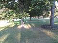
The hashyard

Obligatory Stupid Grin
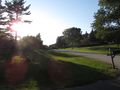
The area of the hash


