Difference between revisions of "2015-09-28 63 28"
From Geohashing
imported>Pastori (Created page with "{{meetup graticule | lat=63 | lon=28 | date=2015-09-28 }} __NOTOC__ == Location == Valtimo, Pajukoski. The point lies in a spruce forest, on the bank of a ditch. == Particip...") |
imported>FippeBot m (Location) |
||
| Line 38: | Line 38: | ||
[[Category:Expeditions with photos]] | [[Category:Expeditions with photos]] | ||
[[Category:Coordinates reached]] | [[Category:Coordinates reached]] | ||
| + | {{location|FI|13}} | ||
Latest revision as of 05:17, 15 August 2019
| Mon 28 Sep 2015 in 63,28: 63.5874809, 28.6473152 geohashing.info google osm bing/os kml crox |
Location
Valtimo, Pajukoski. The point lies in a spruce forest, on the bank of a ditch.
Participants
- Pastori
- The Wife
Expedition

Once again we have a speedy accomplishment from Pastori and Wife. After breakfast, they drove for 29 kilometres. The hashpoint was 7 metres from the road and they achieved an accuracy of 2,3 metres. Piece of cake. They didn't catch anything besides some fresh air and a stroll through the woods; no mushrooms or berries or even deer flies. So, they went home to wait for new ”challenges”.
Additional photos
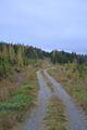
Typical North Karelian forest road and scenery.
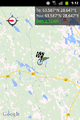
The GPS proof.


Achievements
Pastori and The Wife earned the Land geohash achievement
|