Difference between revisions of "2015-11-08 49 11"
From Geohashing
imported>Klaus (plans) |
imported>Klaus (expedition) |
||
| Line 1: | Line 1: | ||
| − | + | [[Image:{{{image|2015-11-08 49 11 field with geohash.jpg}}}|thumb|left]] | |
| − | |||
| − | |||
| − | |||
| − | |||
| − | |||
| − | |||
| − | |||
{{meetup graticule | {{meetup graticule | ||
| lat=49 | | lat=49 | ||
| Line 15: | Line 8: | ||
}} | }} | ||
| − | |||
__NOTOC__ | __NOTOC__ | ||
| Line 22: | Line 14: | ||
== Participants == | == Participants == | ||
| − | * [[User:Klaus|Klaus]] | + | * [[User:Klaus|Klaus]] and parts of his family |
== Plans == | == Plans == | ||
| Line 30: | Line 22: | ||
== Expedition == | == Expedition == | ||
| − | + | We did an afternoon walk and arrived at around 14:50 at the field where the geohash was. | |
| + | Luckily, the field was not too muddy, so I walked to the geohash while the rest of my family was staying on the track. | ||
== Tracklog == | == Tracklog == | ||
| − | + | none this time | |
== Photos == | == Photos == | ||
| − | |||
| − | |||
| − | |||
<gallery perrow="5"> | <gallery perrow="5"> | ||
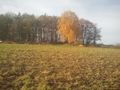
| + | Image:2015-11-08 49 11 field with geohash.jpg | The field with the geohash | ||
| + | Image:2015-11-08 49 11 proof.jpg | Proof (quite blurry, but note the green distance) | ||
| + | Image:2015-11-08 49 11 view from geohash1.jpg | View from geohash 1 | ||
| + | Image:2015-11-08 49 11 view from geohash2.jpg | View from geohash 2 | ||
| + | Image:2015-11-08 49 11 view from geohash3.jpg | View from geohash 3 | ||
| + | Image:2015-11-08_49_11_view_hohenpoelz.jpg | nice view to Hohenpölz, around 100m from the geohash | ||
</gallery> | </gallery> | ||
== Achievements == | == Achievements == | ||
{{#vardefine:ribbonwidth|800px}} | {{#vardefine:ribbonwidth|800px}} | ||
| − | |||
| − | [[ | + | {{land geohash |
| + | | latitude = 49 | ||
| + | | longitude = 11 | ||
| + | | date = 2015-11-08 | ||
| + | | name = [[User:Klaus|Klaus]] | ||
| + | }} | ||
| − | + | {{Walk geohash | |
| + | | latitude = 49 | ||
| + | | longitude = 11 | ||
| + | | date = 2015-11-08 | ||
| + | | name = [[User:Klaus|Klaus]] | ||
| + | }} | ||
| − | |||
| − | |||
| − | |||
| − | |||
| − | |||
| − | |||
| − | |||
| − | |||
| − | |||
| − | |||
| − | |||
| − | |||
| − | |||
| − | |||
| − | |||
| − | |||
| − | |||
| − | |||
| − | |||
| − | |||
| − | |||
| − | |||
| − | |||
| − | + | [[Category:Expeditions]] | |
| + | [[Category:Expeditions with photos]] | ||
| + | [[Category:Coordinates reached]] | ||
Revision as of 15:31, 8 November 2015

| Sun 8 Nov 2015 in 49,11: 49.9053471, 11.1586973 geohashing.info google osm bing/os kml crox |
Location
in a field between Hohenpölz und Brunn
Participants
- Klaus and parts of his family
Plans
I'm visiting my parents and this geohash is very near to where they live. Plan is to grab a bicycle, cycle there and cash the easy hash on Sunday, probably after noon at around 14:00.
Expedition
We did an afternoon walk and arrived at around 14:50 at the field where the geohash was. Luckily, the field was not too muddy, so I walked to the geohash while the rest of my family was staying on the track.
Tracklog
none this time
Photos
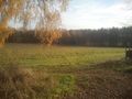
The field with the geohash
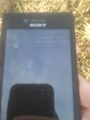
Proof (quite blurry, but note the green distance)
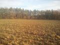
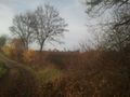
View from geohash 1
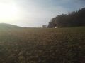
View from geohash 2
View from geohash 3
nice view to Hohenpölz, around 100m from the geohash


Achievements
Klaus earned the Land geohash achievement
|
Klaus earned the Walk geohash Achievement
|