Difference between revisions of "2015-11-10 52 5"
From Geohashing
imported>Xnyhps |
imported>Xnyhps m |
||
| Line 30: | Line 30: | ||
== Expedition == | == Expedition == | ||
| + | === xnyhps === | ||
Well, the no rain turned out to be wrong, there was a drizzle the entire trip. The route turned out quite nice, almost entirely through forest. The point itself was about 10m from an intersection of paths through a forest (which were both not on OSM, so another achievement I can get here!). Managed to get to 0.6 m, so my first geohash success! | Well, the no rain turned out to be wrong, there was a drizzle the entire trip. The route turned out quite nice, almost entirely through forest. The point itself was about 10m from an intersection of paths through a forest (which were both not on OSM, so another achievement I can get here!). Managed to get to 0.6 m, so my first geohash success! | ||
| Line 66: | Line 67: | ||
[[Category:Expeditions]] | [[Category:Expeditions]] | ||
| − | |||
| − | |||
| − | |||
| − | |||
| − | |||
| − | |||
| − | |||
| − | |||
| − | |||
| − | |||
| − | |||
| − | |||
| − | |||
| − | |||
| − | |||
[[Category:Expeditions with photos]] | [[Category:Expeditions with photos]] | ||
| − | |||
| − | |||
| − | |||
| − | |||
| − | |||
[[Category:Coordinates reached]] | [[Category:Coordinates reached]] | ||
| − | |||
| − | |||
| − | |||
| − | |||
| − | |||
| − | |||
| − | |||
| − | |||
| − | |||
| − | |||
| − | |||
| − | |||
| − | |||
| − | |||
| − | |||
| − | |||
| − | |||
| − | |||
Revision as of 20:01, 10 November 2015
| Tue 10 Nov 2015 in 52,5: 52.0818643, 5.3245593 geohashing.info google osm bing/os kml crox |
Location
Forest near Austerlitz.
Participants
Plans
xnyhps
This was pretty close - only about 8 km. I planned a nice route by bike that would also allow me to throw some nice Ingress fields too. Weather was looking nice, not too cold and no rain.
Expedition
xnyhps
Well, the no rain turned out to be wrong, there was a drizzle the entire trip. The route turned out quite nice, almost entirely through forest. The point itself was about 10m from an intersection of paths through a forest (which were both not on OSM, so another achievement I can get here!). Managed to get to 0.6 m, so my first geohash success!
Tracklog
Photos
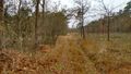
The path to the geohash.
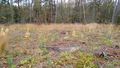
The geohash location is somewhere around here.
Proof.


Achievements
xnyhps earned the Land geohash achievement
|
xnyhps earned the Bicycle geohash achievement
|