Difference between revisions of "2016-01-03 48 11"
imported>Lord Vetinari (Created page with " <!-- If you did not specify these parameters in the template, please substitute appropriate values for IMAGE, LAT, LON, and DATE (YYYY-MM-DD format) Image:{{{image|IMAGE}...") |
imported>Lord Vetinari m (→Achievements) |
||
| Line 59: | Line 59: | ||
{{land geohash | {{land geohash | ||
| − | + | | latitude=48 | |
| − | + | | longitude=11 | |
| − | + | | date=2016-01-03 | |
| name = Lord_Vetinari | | name = Lord_Vetinari | ||
}} | }} | ||
Revision as of 04:32, 10 January 2016
| Sun 3 Jan 2016 in 48,11: 48.0336429, 11.8717493 geohashing.info google osm bing/os kml crox |
Location
On a football field in Moosach (Landkreis Ebersberg)
Participants
- Lord Vetinari
- Lady Vetinari (not a user here... yet)
Plans
We intended to go on a small Sunday hike and were looking if we could combine it with a hashpoint. And indeed, there was one not too far away.
Expedition
Starting from the north-east of Munich by car, it took us about 30 minutes drive to get to the hashpoint, going through some foggy woods. As the hashpoint was in the middle of a football field, there was ample parking nearby and the location was easily reached.
Leaving our car near the hashpoint, we embarked on a hike (about 6km) to and around the nearby Steinsee. We decided to eat at a restaurant on the shores on the Steinsee, but went back to get the car first as it was already quickly getting darker.
The meal was very delicious (pike-perch fillet for me), the hike through the snowy landscape very nice and the hashpoint easily reached, so it was a very enjoyable Sunday for me.
Photos
Lord Vetinaris gallery
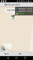
The hash's location marked with an X
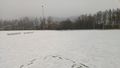
Proof

The hasher plus somewhat sceptical but supportive company
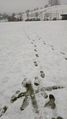
The rest of the football field
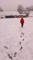
Walking back
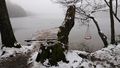
The Steinsee visited later


Achievements
Lord_Vetinari earned the Land geohash achievement
|