Difference between revisions of "2016-01-04 50 7"
imported>Burgman (Created page with "{{meetup graticule | map=<map lat="50" lon="7" date="2016-01-04" /> | lat=50 | lon=7 | date=2016-01-04 | graticule_name=Bonn | graticule_link=Bonn, Germany}} == Location == A...") |
imported>Burgman m (Added photos) |
||
| Line 17: | Line 17: | ||
== Expedition == | == Expedition == | ||
| − | I had to do the driving without navigation system this time so I studied the map carefully and reached the end of the Eiserweg just as I had planned. It was short before 7 p.m. so it was dark | + | I had to do the driving without navigation system this time so I studied the map carefully and reached the end of the Eiserweg just as I had planned. It was short before 7 p.m. so it was dark. |
| − | Half blinded I performed the usual geo dance (oh, a tree stump! | + | The small path started between a row of houses and a closed cemetery. I crossed a short catwalk over a rivulet and stood in the darkness of a small wood. Only some dozen steps to go. My tiny torch did not help me much because of the blinding light in the back of a house just near the hash - two floodlights shone over a garden wall at the height of my head. Too much light to adapt the eyes to the darkness below. I could neither see my feet nor the ground but I heard that I was walking on very wet ground. We had rain in the last two days. Well, mud again... |
| + | |||
| + | Half blinded I performed the usual geo dance (oh, a tree stump! oh, a bough...), made my photos and left the wet wood with the strange light conditions. | ||
== Photos == | == Photos == | ||
<gallery> | <gallery> | ||
| − | + | File:2016-01-04-50-7-01.jpg|Compass | |
| + | File:2016-01-04-50-7-02.jpg|Standard proof | ||
| + | File:2016-01-04-50-7-03.jpg|In the lighted darkness, probably with a Stupid Grin (TM) | ||
</gallery> | </gallery> | ||
Revision as of 22:15, 5 January 2016
| Mon 4 Jan 2016 in Bonn: 50.9073868, 7.1554141 geohashing.info google osm bing/os kml crox |
Contents
Location
A small path in Rösrath.
Participants
Plans
According to the map the hash was in Rösrath at the Kirchstraße behind some houses. It should be easy to get there because a street was nearby and a small path lead to it even from the street.
Expedition
I had to do the driving without navigation system this time so I studied the map carefully and reached the end of the Eiserweg just as I had planned. It was short before 7 p.m. so it was dark.
The small path started between a row of houses and a closed cemetery. I crossed a short catwalk over a rivulet and stood in the darkness of a small wood. Only some dozen steps to go. My tiny torch did not help me much because of the blinding light in the back of a house just near the hash - two floodlights shone over a garden wall at the height of my head. Too much light to adapt the eyes to the darkness below. I could neither see my feet nor the ground but I heard that I was walking on very wet ground. We had rain in the last two days. Well, mud again...
Half blinded I performed the usual geo dance (oh, a tree stump! oh, a bough...), made my photos and left the wet wood with the strange light conditions.
Photos
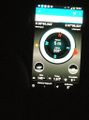
Compass
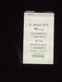
Standard proof
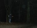
In the lighted darkness, probably with a Stupid Grin (TM)


