imported>Sourcerer m (→Usage) |
imported>Sourcerer m (→Fixed link) |
||
| Line 5: | Line 5: | ||
This [http://nbest.co.uk/kmlGeohash/testForm.php calculator] creates and downloads KML hashpoint data including the globalhash. | This [http://nbest.co.uk/kmlGeohash/testForm.php calculator] creates and downloads KML hashpoint data including the globalhash. | ||
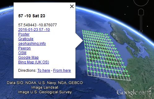
| − | If you install [ | + | If you install [https://www.google.com/earth/versions/#earth-pro Google Earth Desktop] or other applications such as [https://marble.kde.org/ Marble] that understand this file format, they should launch and display the hashpoints for your specified date and graticule. Surprisingly this worked on my old Android phone. The kml data auto-launched a Google map app and there were the hashpoints with their links to the other tools. |
[[File:Sourcerer KML.jpg]] | [[File:Sourcerer KML.jpg]] | ||
Latest revision as of 08:35, 10 January 2019
| This implementation IS FULLY 30W-compliant. |
Please double check the output - it's been tested but ...
This calculator creates and downloads KML hashpoint data including the globalhash.
If you install Google Earth Desktop or other applications such as Marble that understand this file format, they should launch and display the hashpoints for your specified date and graticule. Surprisingly this worked on my old Android phone. The kml data auto-launched a Google map app and there were the hashpoints with their links to the other tools.
Usage
Use this input form or modify the web address below ...
http://nbest.co.uk/kmlGeohash/index.php?date=2016-01-31&lat=52&lon=-1&clat=52.5&clon=1.5&skins=3
If any URL parameter is omitted, a default value is used instead.
- date - formatted yyyy-mm-dd - the default is today's date - alternatively try for example, 1 for tomorrow or -2 for the day before yesterday.
- lat - graticule latitude - the default is 51 (Grenwich London) - whole numbers please.
- lon - graticule longitude - the default is 0 (Grenwich London) - whole numbers please.
- clat - view centre latitude - It's OK to leave this blank.
- clon - view centre longitude - It's OK to leave this blank.
- skins - like an onion, the number of layers of points surrounding the home point - the default is 1 giving 9 hashpoints - the limits are 0 to 6.
- debug - check this or add '&debug=debug' to expose the guts of the algorithm.
Bugs and feature requests
Please put bug reports and feature requests on the discussion tab.
- Google earth street view is very useful if your country allows this.
- UK geohashers will like the Bing Map (UK OS) link. This shows the hashpoint and rights of way for access.
