Difference between revisions of "2016-01-24 60 26"
imported>FelixTheCat (Created page with "{{subst:Expedition |lat = 60 |lon = 26 |date = 2016-01-24 }}") |
imported>FelixTheCat |
||
| Line 1: | Line 1: | ||
| − | |||
| − | |||
| − | |||
| − | |||
| − | |||
| − | |||
| − | |||
| − | |||
| − | |||
| − | |||
{{meetup graticule | {{meetup graticule | ||
| lat=60 | | lat=60 | ||
| Line 15: | Line 5: | ||
}} | }} | ||
| − | |||
__NOTOC__ | __NOTOC__ | ||
== Location == | == Location == | ||
| − | + | On a forest road just off Main Road 12, halfway between Lahti and Kouvola. | |
== Participants == | == Participants == | ||
| − | + | [[User:FelixTheCat|FelixTheCat]] ([[User talk:FelixTheCat|talk]]) | |
| − | |||
== Plans == | == Plans == | ||
| − | + | I happened to be in Finland for the weekend, and this hash popped up on Sunday in a location that seemed reasonably reachable. It was located exactly on a forest road, but how accessible that road would be in winter, with fresh snow having fallen the previous night, was unclear. | |
== Expedition == | == Expedition == | ||
| − | + | Driving along the number 12 road I spotted the exit to the narrow forest road just a bit too late and missed it (cannot brake very hard on a snowy road) and had to turn around about 1 km down the road. The first part of the road was quite driveable. The snow was packed and the road relatively wide. As I went deeper into the forest, the road became narrower and narrower, and the snow thicker and thicker. I very carefully drove the last 500 m towards the hash, and reached the point pretty easily. I then had to reverse that same distance because I didn't want to risk doing a 3-point-turn on such a narrow road with such a thick layer of snow. This all went pretty smoothly and I was soon back on the big road and on my way to Kouvola. | |
| − | + | My first hash in a foreign country, and also my first Frozen Geohash! | |
| − | |||
== Photos == | == Photos == | ||
| − | |||
| − | |||
| − | |||
<gallery perrow="5"> | <gallery perrow="5"> | ||
| + | Image:2016-01-24 60 26 FelixTheCat 1.JPG | Entering the forest road. | ||
| + | Image:2016-01-24 60 26 FelixTheCat 2.JPG | A bit hard to see, but it's definitely -3 °C. | ||
| + | Image:2016-01-24 60 26 FelixTheCat 5.png | And we've arrived! | ||
| + | Image:2016-01-24 60 26 FelixTheCat 3.JPG | Lloyd posing at the hash. | ||
| + | Image:2016-01-24 60 26 FelixTheCat 4.JPG | The hashmobile parked exactly at the spot. | ||
</gallery> | </gallery> | ||
== Achievements == | == Achievements == | ||
{{#vardefine:ribbonwidth|800px}} | {{#vardefine:ribbonwidth|800px}} | ||
| − | + | {{Frozen Geohash | |
| − | |||
| − | |||
| − | |||
| − | |||
| − | |||
| − | |||
| − | |||
| − | |||
| − | |||
| − | + | | latitude = 60 | |
| + | | longitude = 26 | ||
| + | | date = 2016-01-24 | ||
| + | | temperature = -3 °C | ||
| + | | name = [[User:FelixTheCat|FelixTheCat]] ([[User talk:FelixTheCat|talk]]) | ||
| + | | image = 2016-01-24 60 26 FelixTheCat 4.JPG | ||
| − | + | }} | |
[[Category:Expeditions]] | [[Category:Expeditions]] | ||
| − | |||
[[Category:Expeditions with photos]] | [[Category:Expeditions with photos]] | ||
| − | |||
| − | |||
| − | |||
| − | |||
| − | |||
[[Category:Coordinates reached]] | [[Category:Coordinates reached]] | ||
| − | |||
| − | |||
| − | |||
| − | |||
| − | |||
| − | |||
| − | |||
| − | |||
| − | |||
| − | |||
| − | |||
| − | |||
| − | |||
| − | |||
| − | |||
| − | |||
| − | |||
| − | |||
Revision as of 21:07, 26 January 2016
| Sun 24 Jan 2016 in 60,26: 60.8970627, 26.2109631 geohashing.info google osm bing/os kml crox |
Location
On a forest road just off Main Road 12, halfway between Lahti and Kouvola.
Participants
Plans
I happened to be in Finland for the weekend, and this hash popped up on Sunday in a location that seemed reasonably reachable. It was located exactly on a forest road, but how accessible that road would be in winter, with fresh snow having fallen the previous night, was unclear.
Expedition
Driving along the number 12 road I spotted the exit to the narrow forest road just a bit too late and missed it (cannot brake very hard on a snowy road) and had to turn around about 1 km down the road. The first part of the road was quite driveable. The snow was packed and the road relatively wide. As I went deeper into the forest, the road became narrower and narrower, and the snow thicker and thicker. I very carefully drove the last 500 m towards the hash, and reached the point pretty easily. I then had to reverse that same distance because I didn't want to risk doing a 3-point-turn on such a narrow road with such a thick layer of snow. This all went pretty smoothly and I was soon back on the big road and on my way to Kouvola.
My first hash in a foreign country, and also my first Frozen Geohash!
Photos
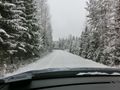
Entering the forest road.
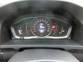
A bit hard to see, but it's definitely -3 °C.
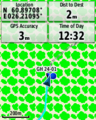
And we've arrived!
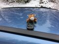
Lloyd posing at the hash.
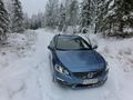
The hashmobile parked exactly at the spot.


Achievements
FelixTheCat (talk) earned the Frozen Geohash Achievement
|