Difference between revisions of "2016-01-28 51 9"
From Geohashing
imported>GeorgDerReisende (new report) |
imported>GeorgDerReisende (expedition report for Großalmerode-Rommerode) |
||
| Line 1: | Line 1: | ||
| − | |||
| − | |||
| − | |||
| − | |||
| − | |||
| − | |||
| − | |||
| − | |||
| − | |||
| − | |||
{{meetup graticule | {{meetup graticule | ||
| lat=51 | | lat=51 | ||
| Line 19: | Line 9: | ||
== Location == | == Location == | ||
| − | + | ||
| + | The hash lay on a meadow behind Rommerode. | ||
== Participants == | == Participants == | ||
| − | + | ||
| − | + | [[User:GeorgDerReisende|GeorgDerReisende]] | |
== Plans == | == Plans == | ||
| − | + | ||
| + | Hitchhiking and walking. | ||
== Expedition == | == Expedition == | ||
| − | |||
| − | + | I left home at 12:00, started to hitchhike at 12:30, and with four cars I arrived at Rommerode at 14:30. Then I walked to the hash. I found it on an open meadow. Then I walked back to Rommerode. There I started to hitchhike at 15:50 and with one car I arrived at Kassel at 17:00. | |
| − | |||
== Photos == | == Photos == | ||
| − | |||
| − | |||
| − | |||
<gallery perrow="5"> | <gallery perrow="5"> | ||
| + | Image: 2016-01-28 51 9 GeorgDerReisende 8659.jpg | 120 m to hash | ||
| + | Image: 2016-01-28 51 9 GeorgDerReisende 8666.jpg | arrived! | ||
| + | Image: 2016-01-28 51 9 GeorgDerReisende 8668.jpg | the north | ||
| + | Image: 2016-01-28 51 9 GeorgDerReisende 8669.jpg | the east | ||
| + | Image: 2016-01-28 51 9 GeorgDerReisende 8670.jpg | the south | ||
| + | Image: 2016-01-28 51 9 GeorgDerReisende 8671.jpg | the west | ||
| + | Image: 2016-01-28 51 9 GeorgDerReisende 8672.jpg | the geohasher | ||
| + | Image: 2016-01-28 51 9 GeorgDerReisende 8681.jpg | the southeast behind the bushes | ||
| + | Image: 2016-01-28 51 9 GeorgDerReisende 8709.jpg | main street of Rommerode | ||
</gallery> | </gallery> | ||
| Line 45: | Line 41: | ||
<!-- Add any achievement ribbons you earned below, or remove this section --> | <!-- Add any achievement ribbons you earned below, or remove this section --> | ||
| − | + | {{Thumbs Up | latitude = 51 | longitude = 9 | date = 2016-01-28 | name = GeorgDerReisende }} | |
| − | |||
| − | |||
| − | + | [[Category:Expeditions]] | |
| − | |||
| − | [[Category: | ||
| − | |||
| − | + | [[Category:Expeditions with photos]] | |
| − | |||
| − | |||
| − | |||
| − | |||
| − | |||
| − | |||
| − | |||
| − | |||
| − | |||
[[Category:Coordinates reached]] | [[Category:Coordinates reached]] | ||
| − | |||
| − | |||
| − | |||
| − | |||
| − | |||
| − | |||
| − | |||
| − | |||
| − | |||
| − | |||
| − | |||
| − | |||
| − | |||
| − | |||
| − | |||
| − | |||
| − | |||
| − | |||
Revision as of 17:13, 28 January 2016
| Thu 28 Jan 2016 in 51,9: 51.2315504, 9.7837153 geohashing.info google osm bing/os kml crox |
Location
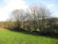
The hash lay on a meadow behind Rommerode.
Participants
Plans
Hitchhiking and walking.
Expedition
I left home at 12:00, started to hitchhike at 12:30, and with four cars I arrived at Rommerode at 14:30. Then I walked to the hash. I found it on an open meadow. Then I walked back to Rommerode. There I started to hitchhike at 15:50 and with one car I arrived at Kassel at 17:00.
Photos
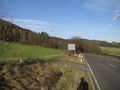
120 m to hash
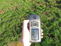
arrived!
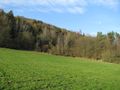
the north
the east
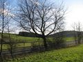
the south
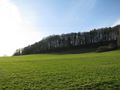
the west
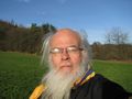
the geohasher
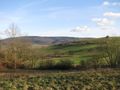
the southeast behind the bushes
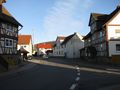
main street of Rommerode


Achievements
GeorgDerReisende earned the Thumbs Up Geohash Achievement
|