Difference between revisions of "2016-02-29 54 10"
imported>ZettS (Created page with "<!-- If you did not specify these parameters in the template, please substitute appropriate values for IMAGE, LAT, LON, and DATE (YYYY-MM-DD format) Image:{{{image|IMAGE}}...") |
imported>ZettS |
||
| Line 29: | Line 29: | ||
== Expedition == | == Expedition == | ||
| + | The Expedition started around 8:30 am at my bus stop, where I took the bus to the central station. The bus port is currently under construction, so the different buses depart from various bus stops around the central station and so I went first to the wrong bus stop. But after a short sprint I luckily reached the right bus stop in time. | ||
| + | |||
| + | The bus drove through the little towns of Raisdorf and Preetz finally arrived at the stop in "Sophienhof". It was cold and a bit windy, but ok. The last metres to the hashpoint I went on foot, reached the field, placed a marker and took photos. | ||
| + | |||
| + | This time I was better prepared and had the coordinates for the nearby [http://coord.info/GC4D60P Geocache] which was araound 84 m apart. This time I signed in the logbook. Near this cache are the remains of the old B76, a curve of the former road. | ||
| + | |||
| + | Half an hour later the bus took me back to Preetz where I changed for the regional train to get back to Kiel. | ||
| + | |||
| + | |||
| + | [[File:2016-02-29_54_10_panorama.JPG|left|1000px]] | ||
| − | |||
<gallery> | <gallery> | ||
| − | Image:.JPG| | + | Image:2016-02-29_54_10_bus.JPG|The bus number 4330 to Plön |
| − | Image:.JPG| | + | Image:2016-02-29_54_10_sophienhof.JPG|The little village |
| − | Image:.JPG| | + | Image:2016-02-29_54_10_road.JPG|Last metres to the hashpoint |
| − | Image:.JPG| | + | Image:2016-02-29_54_10_proof.JPG|Proof |
| − | Image:.JPG| | + | Image:2016-02-29_54_10_marker.JPG|The internet was here... |
| − | Image:.JPG| | + | Image:2016-02-29_54_10_grin.JPG|...and ZettS too |
| − | Image:.JPG| | + | Image:2016-02-29_54_10_cache1.JPG|Distance to the Geocache |
| + | Image:2016-02-29_54_10_cache2.JPG|Found it! | ||
| + | Image:2016-02-29_54_10_B76.JPG|Part of the old B76 | ||
| + | Image:2016-02-29_54_10_wayback.JPG|On the train back to Kiel | ||
</gallery> | </gallery> | ||
| − | + | ||
| + | |||
| + | |||
| + | |||
==Achievements== | ==Achievements== | ||
| + | |||
| + | {{Leap geohash | ||
| + | |year=2016 | ||
| + | |lat=54 | ||
| + | |lon=10 | ||
| + | |name=[[User:ZettS|ZettS]] | ||
| + | }} | ||
| + | |||
| + | {{Hash collision | ||
| + | | latitude = 54 | ||
| + | | longitude = 10 | ||
| + | | date = 2016-02-29 | ||
| + | | name = [[User:ZettS|ZettS]] | ||
| + | | id = GC4D60P | ||
| + | | link = http://coord.info/GC4D60P | ||
| + | | distance = 84 m | ||
| + | | honor = 1 | ||
| + | }} | ||
| + | |||
| + | {{Public transport geohash | ||
| + | | latitude = 54 | ||
| + | | longitude = 10 | ||
| + | | date = 2016-02-29 | ||
| + | | name = [[User:ZettS|ZettS]] | ||
| + | }} | ||
| + | |||
| − | [[Category: | + | [[Category:Expeditions]] |
| − | + | [[Category:Expeditions with photos]] | |
| + | [[Category:Coordinates reached]] | ||
[[Category:Meetup on 2016-02-29]] | [[Category:Meetup on 2016-02-29]] | ||
[[Category:Meetup in 54 10]] | [[Category:Meetup in 54 10]] | ||
Revision as of 20:05, 29 February 2016
| Mon 29 Feb 2016 in 54,10: 54.2073451, 10.3392128 geohashing.info google osm bing/os kml crox |
Location
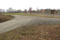
A field south of Sophienhof/Preetz, near the B76.
Participants
Plans
It's a leap day, so I will try to get there in the morning -- ZettS (talk) 02:44, 28 February 2016 (EST)
Expedition
The Expedition started around 8:30 am at my bus stop, where I took the bus to the central station. The bus port is currently under construction, so the different buses depart from various bus stops around the central station and so I went first to the wrong bus stop. But after a short sprint I luckily reached the right bus stop in time.
The bus drove through the little towns of Raisdorf and Preetz finally arrived at the stop in "Sophienhof". It was cold and a bit windy, but ok. The last metres to the hashpoint I went on foot, reached the field, placed a marker and took photos.
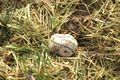
This time I was better prepared and had the coordinates for the nearby Geocache which was araound 84 m apart. This time I signed in the logbook. Near this cache are the remains of the old B76, a curve of the former road.
Half an hour later the bus took me back to Preetz where I changed for the regional train to get back to Kiel.


The bus number 4330 to Plön
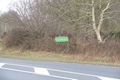
The little village

Last metres to the hashpoint
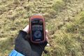
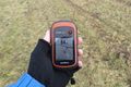
Proof
The internet was here...
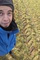
...and ZettS too
Distance to the Geocache
Found it!
Part of the old B76
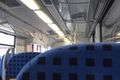
On the train back to Kiel


Achievements

ZettS earned the Hash collision honorable mention
|
ZettS earned the Public transport geohash achievement
|