Difference between revisions of "2016-04-27 52 1"
imported>Sourcerer m ([retro picture] Foiled. [http://www.openstreetmap.org/?lat=52.71824956&lon=1.53787136&zoom=16&layers=B000FTF @52.7182,1.5379]) |
imported>Sourcerer m (→New expedition) |
||
| Line 1: | Line 1: | ||
| − | + | {{meetup graticule | |
| − | |||
| − | |||
| − | |||
| − | |||
| − | |||
| − | |||
| − | |||
| − | |||
| − | |||
| − | {{meetup graticule | ||
| lat=52 | | lat=52 | ||
| lon=1 | | lon=1 | ||
| date=2016-04-27 | | date=2016-04-27 | ||
| + | | graticule_name=Norwich, UK | ||
| + | | graticule_link=Norwich, United Kingdom | ||
}} | }} | ||
| − | |||
| − | |||
__NOTOC__ | __NOTOC__ | ||
| + | == Location == | ||
| − | + | A field north of Ludham, Norfolk, UK. | |
| − | |||
== Participants == | == Participants == | ||
| − | + | ||
| − | + | *[[User:Sourcerer|Sourcerer]] | |
== Plans == | == Plans == | ||
| − | + | ||
| + | Two of two spanning midnight - [[2016-04-26 52 1]] - [[2016-04-27 52 1]] - ETA 00:00. | ||
== Expedition == | == Expedition == | ||
| − | |||
| − | + | Already defeated and quite damp after expedition one, this evening, this did not look hopeful. In foul weather the path towards the hashpoint looked more like a lake or large pond. An alternative approach was little better. There was another less honourable reason to avoiding another soaking. It would be fun if the Norwich graticule appeared in every position in the top ten most active graticules. As long as no-one else goes on a local expedition this month, two more positions in the tables will be filled. This is glorified "colouring in"! | |
| − | |||
== Photos == | == Photos == | ||
| − | + | ||
| − | |||
| − | |||
<gallery perrow="5"> | <gallery perrow="5"> | ||
| − | |||
Image:2016-04-27_52_1_Sourcerer_1461711591326.jpg | Foiled. [http://www.openstreetmap.org/?lat=52.71824956&lon=1.53787136&zoom=16&layers=B000FTF @52.7182,1.5379] | Image:2016-04-27_52_1_Sourcerer_1461711591326.jpg | Foiled. [http://www.openstreetmap.org/?lat=52.71824956&lon=1.53787136&zoom=16&layers=B000FTF @52.7182,1.5379] | ||
| + | Image:2016-04-27 52 1 Sourcerer.jpg | Google Earth Track | ||
</gallery> | </gallery> | ||
== Achievements == | == Achievements == | ||
{{#vardefine:ribbonwidth|800px}} | {{#vardefine:ribbonwidth|800px}} | ||
| − | |||
| − | + | {{Sourcerer_links | |
| − | + | | prev = 2016-04-26 52 1 | |
| − | + | | curr = 2016-04-27 52 1 | |
| + | | next = 2016-05-01 52 1 | ||
| + | | date = 2016-04-27 | ||
| + | }} | ||
| − | |||
| − | |||
| − | |||
| − | |||
| − | |||
| − | |||
| − | |||
| − | |||
[[Category:Expeditions]] | [[Category:Expeditions]] | ||
| − | |||
[[Category:Expeditions with photos]] | [[Category:Expeditions with photos]] | ||
| − | |||
| − | |||
| − | |||
| − | |||
| − | |||
| − | |||
| − | |||
| − | |||
| − | |||
[[Category:Coordinates not reached]] | [[Category:Coordinates not reached]] | ||
| − | |||
| − | |||
| − | |||
| − | |||
| − | |||
| − | |||
| − | |||
| − | |||
| − | |||
| − | |||
| − | |||
| − | |||
| − | |||
| − | |||
Revision as of 00:28, 27 April 2016
| Wed 27 Apr 2016 in Norwich, UK: 52.7179363, 1.5333387 geohashing.info google osm bing/os kml crox |
Location
A field north of Ludham, Norfolk, UK.
Participants
Plans
Two of two spanning midnight - 2016-04-26 52 1 - 2016-04-27 52 1 - ETA 00:00.
Expedition
Already defeated and quite damp after expedition one, this evening, this did not look hopeful. In foul weather the path towards the hashpoint looked more like a lake or large pond. An alternative approach was little better. There was another less honourable reason to avoiding another soaking. It would be fun if the Norwich graticule appeared in every position in the top ten most active graticules. As long as no-one else goes on a local expedition this month, two more positions in the tables will be filled. This is glorified "colouring in"!
Photos
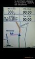
Foiled. @52.7182,1.5379
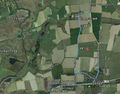
Google Earth Track


Achievements
Expeditions and Plans
| 2016-04-27 | ||
|---|---|---|
| Grand Rapids, Michigan | Mcbaneg | Near the end of runway 12, Lowell City Airport, Lowell, MI |
| Stuttgart, Germany | Drei aus Korb | Ebersbach an der Fils, Germany |
| Norwich, United Kingdom | Sourcerer | A field north of Ludham, Norfolk, UK. |
Sourcerer's Expedition Links
2016-04-26 52 1 - 2016-04-27 52 1 - 2016-05-01 52 1 - KML file download of Sourcerer's expeditions for use with Google Earth.