Difference between revisions of "2016-04-28 49 10"
imported>Nicole1338 (→Tracklog) |
imported>Sourcerer m (→Fixed New report status) |
||
| Line 82: | Line 82: | ||
[[Category:Expeditions with photos]] | [[Category:Expeditions with photos]] | ||
[[Category:Coordinates reached]] | [[Category:Coordinates reached]] | ||
| − | |||
| − | |||
| − | |||
| − | |||
| − | |||
| − | |||
| − | |||
| − | |||
| − | |||
| − | |||
| − | |||
| − | |||
| − | |||
| − | |||
| − | |||
| − | |||
| − | |||
| − | |||
| − | |||
| − | |||
| − | |||
| − | |||
| − | |||
| − | |||
| − | |||
| − | |||
| − | |||
| − | |||
| − | |||
| − | |||
| − | |||
| − | |||
| − | |||
| − | |||
| − | |||
| − | |||
| − | |||
| − | |||
| − | |||
| − | |||
Revision as of 15:55, 14 June 2016
| Thu 28 Apr 2016 in 49,10: 49.5355529, 10.9962233 geohashing.info google osm bing/os kml crox |
Location
Meadow on a border to a privat property in Kleingründlach.
Participants
Plans
I was at work when I recognized that a geohash is not far away from me. Finally. I looked at the map and I decided to drive directly from work to the geohash. I know this area very well from geocaching, so I was in good spirits to find this place without problems.
Expedition
Finally, end of the work day. I was very excited to go to my first geohash point today. The weather was not bad, just a little bit cold and sometimes even the sun came out. I started from work and it was just about 3 km of driving away from me, but oh no.. there's a working site on the street which led to the hashpoint. Now I regret, that I haven't took the bike early today. After another 6 km and 10 minutes of driving I parked about 150 meter away from the point and I walked the remaining meters along the street. Shortly before the finish was a small ditch, the Kesselgraben. There were two possibilities to get around: Walk another 60 Meter to a small bridge or just jump over it. I decided for the second option. :) Another 10 meters of meadow between me and the point and finally I reached it!
I was very happy that I could finally made it to my first geohash today.
Tracklog
| I forgot to track my route, so here is a picture from the last part of my route and the detour because of the construction site. | 
|
Photos
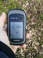
arrived@49.5470,11.0195
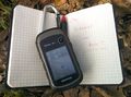
The Internet was here@49.5470,11.0195
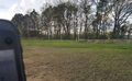
View to the north@49.5470,11.0195
View to the west@49.5470,11.0195
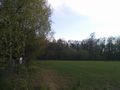
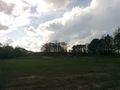
View to the south@49.5470,11.0195
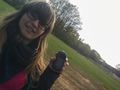
I at ground zero@49.5470,11.0195


Achievements
Nicole1338 earned the Land geohash achievement
|