Difference between revisions of "2016-06-01 52 5"
From Geohashing
imported>JwB m (→Expedition) |
imported>JwB m (→Photos) |
||
| Line 43: | Line 43: | ||
--> | --> | ||
<gallery perrow="5"> | <gallery perrow="5"> | ||
| + | Image:approach160601.jpg | walking up | ||
| + | Image:spot160601.jpg | accessible | ||
| + | Image:Proof2016-06-01-52-5.png | there | ||
</gallery> | </gallery> | ||
Revision as of 06:32, 1 June 2016
| Wed 1 Jun 2016 in 52,5: 52.4777521, 5.5068011 geohashing.info google osm bing/os kml crox |
Location
Between bikepath and motorway on Larserweg, near Lelystad
Participants
Plans
- Very close to my daily commute. Will be there at approx 8 AM
Expedition
As planned. Drove up there and parked near the bikepath. 150 m walk and no impediments made it an easy one.
Tracklog
Photos
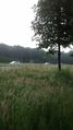
walking up
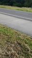
accessible
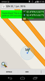
there


Achievements