Difference between revisions of "2016-07-10 49 8"
imported>DODO (→Photos) |
imported>DODO (→Achievements) |
||
| Line 59: | Line 59: | ||
{{#vardefine:ribbonwidth|800px}} | {{#vardefine:ribbonwidth|800px}} | ||
<!-- Add any achievement ribbons you earned below, or remove this section --> | <!-- Add any achievement ribbons you earned below, or remove this section --> | ||
| + | {{land geohash | ||
| + | | latitude = 49 | ||
| + | | longitude = 8 | ||
| + | | date = 2016-07-10 | ||
| + | | name = DODO | ||
| + | }} | ||
| − | + | {{bicycle geohash | |
| − | + | | latitude = 49 | |
| − | + | | longitude = 8 | |
| + | | date = 2016-07-10 | ||
| + | | name = DODO | ||
| + | | distance = 51 KM | ||
| + | }} | ||
| − | |||
| − | |||
| − | |||
| − | |||
| − | |||
| − | |||
| − | |||
| − | |||
| − | |||
| − | |||
[[Category:Expeditions]] | [[Category:Expeditions]] | ||
| − | |||
[[Category:Expeditions with photos]] | [[Category:Expeditions with photos]] | ||
| − | |||
| − | |||
| − | |||
| − | |||
| − | |||
[[Category:Coordinates reached]] | [[Category:Coordinates reached]] | ||
| − | |||
| − | |||
| − | |||
| − | |||
| − | |||
| − | |||
| − | |||
| − | |||
| − | |||
| − | |||
| − | |||
| − | |||
| − | |||
| − | |||
| − | |||
| − | |||
| − | |||
| − | |||
Revision as of 17:08, 10 July 2016
| Sun 10 Jul 2016 in 49,8: 49.5020188, 8.6925195 geohashing.info google osm bing/os kml crox |
Location
On a grassland in the forest above Großsachsen
Participants
Plans
I haven't been hashing for quite a while and I had time today so I decided to visit the hash. The weather was great, sunny but yet not to hot in the morning and so I try to get there by bike.
Expedition
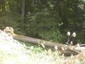
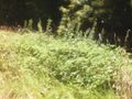
I started at home at 10 am. The wind was gently blowing from the rear and so I came along very quickly. At high noon I was close to the Bergstraße (mountain road) and had to go a little bit upwards into the Odenwald. For the last two kilometers I had to ride some steep gravel paths through the dense forest. Finally, when the path came to an end, there was a surprise to me: a big grassy clearing. I hoped for a good gps-reception and walked into it (although I was pretty sure that it was full with millions of ticks and other raptors). Well, the reception was not good at all and my shown position jumped around wildly, so I walked for more than 15 minutes through the waist-high grass, but finally I got a shot that was good enough.
From here on is not much to tell. I rode back to the street and down to the rhine valley, continued to Weinheim and rode back home by train.
Tracklog
Photos
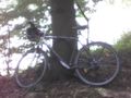
proof of transport
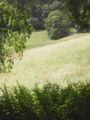
the clearing
proof (kind of)

stupid grin
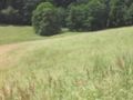
view to the north (east looked the same)
the south
the west
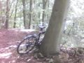
back at my bike


Achievements
DODO earned the Land geohash achievement
|
DODO earned the Bicycle geohash achievement
|