Difference between revisions of "2016-07-15 52 1"
From Geohashing
imported>Sourcerer m (→Achievements) |
imported>Sourcerer m ([live picture] Fail. [http://www.openstreetmap.org/?lat=52.58920312&lon=1.16904080&zoom=16&layers=B000FTF @52.5892,1.1690]) |
||
| Line 26: | Line 26: | ||
<gallery caption="Photo Gallery" widths="200px" heights="200px" perrow="3"> | <gallery caption="Photo Gallery" widths="200px" heights="200px" perrow="3"> | ||
| + | |||
| + | Image:2016-07-15_52_1_Sourcerer_1468619165905.jpg | Fail. [http://www.openstreetmap.org/?lat=52.58920312&lon=1.16904080&zoom=16&layers=B000FTF @52.5892,1.1690] | ||
</gallery> | </gallery> | ||
Revision as of 21:47, 15 July 2016
| Fri 15 Jul 2016 in Norwich, UK: 52.5830345, 1.1722530 geohashing.info google osm bing/os kml crox |
Location
A field close to the A11, near Kett's Oak, Norfolk, UK. This point, south of Park Farm Hotel, looks inaccessible.
Participants
Plans
One of two spanning midnight - 2016-07-15 52 1 - 2016-07-16 52 1 - ETA 22:50.
Expedition
Photos
- Photo Gallery
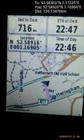
Fail. @52.5892,1.1690

Achievements
Expeditions and Plans
| 2016-07-15 | ||
|---|---|---|
| Melbourne East, Australia | Lachie, Felix Dance | In a field near Arthurs Creek, north of Melbourne |
| Barnstaple, United Kingdom | Tachibana Kanade | located in a forest in Penrice. |
| Eindhoven, Netherlands | pah | Tilburg, NL |
| Norwich, United Kingdom | Sourcerer | A field close to the A11, near Kett's Oak, Norfolk, UK. This point, south o... |
| Hamburg (East), Germany | Koval | Hamburg, Germany. In a field in Rahlstedt, halfway between the residential ... |
Sourcerer's Expedition Links
2016-07-11 52 1 - 2016-07-15 52 1 - 2016-07-16 52 1 - KML file download of Sourcerer's expeditions for use with Google Earth.