Difference between revisions of "2016-07-18 52 1"
From Geohashing
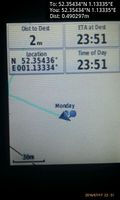
imported>Sourcerer m ([live picture] Proof. [http://www.openstreetmap.org/?lat=52.35433817&lon=1.13334596&zoom=16&layers=B000FTF @52.3543,1.1333]) |
imported>Sourcerer m ([live] Yea midnight.) |
||
| Line 25: | Line 25: | ||
*Waiting for midnight. -- [[User:Sourcerer|Sourcerer]] ([[User talk:Sourcerer|talk]]) [http://www.openstreetmap.org/?lat=52.35433817&lon=1.13334596&zoom=16&layers=B000FTF @52.3543,1.1333] 23:52, 17 July 2016 (GMT+01:00) | *Waiting for midnight. -- [[User:Sourcerer|Sourcerer]] ([[User talk:Sourcerer|talk]]) [http://www.openstreetmap.org/?lat=52.35433817&lon=1.13334596&zoom=16&layers=B000FTF @52.3543,1.1333] 23:52, 17 July 2016 (GMT+01:00) | ||
| + | |||
| + | *Yea midnight. -- [[User:Sourcerer|Sourcerer]] ([[User talk:Sourcerer|talk]]) [http://www.openstreetmap.org/?lat=52.35434353&lon=1.13337278&zoom=16&layers=B000FTF @52.3543,1.1334] 00:00, 18 July 2016 (GMT+01:00) | ||
== Photos == | == Photos == | ||
Revision as of 23:00, 17 July 2016
| Mon 18 Jul 2016 in Norwich, UK: 52.3543422, 1.1333489 geohashing.info google osm bing/os kml crox |
Location
A field south of Stuston, Suffolk, UK.
Participants
Plans
Two of two spanning midnight - 2016-07-17 52 1 - 2016-07-18 52 1 - ETA 00:00.
Expedition
- Waiting for midnight. -- Sourcerer (talk) @52.3543,1.1333 23:52, 17 July 2016 (GMT+01:00)
- Yea midnight. -- Sourcerer (talk) @52.3543,1.1334 00:00, 18 July 2016 (GMT+01:00)
Photos
- Photo Gallery
Proof. @52.3543,1.1333

Achievements
Sourcerer earned the Midnight Geohash achievement
|
Expeditions and Plans
| 2016-07-18 | ||
|---|---|---|
| Canberra, Australia | 1PE | Mugga Lane, within a construction site for roadworks, near the hard rock mi... |
| Kassel, Germany | GeorgDerReisende | In front of a house in Wolfhagen-Viesebeck. |
| Norwich, United Kingdom | Sourcerer | A field south of Stuston, Suffolk, UK. |
Sourcerer's Expedition Links
2016-07-17 52 1 - 2016-07-18 52 1 - 2016-07-19 52 1 - KML file download of Sourcerer's expeditions for use with Google Earth.