Difference between revisions of "2016-07-25 43 -85"
imported>Mcbaneg (Created page with "<!-- If you did not specify these parameters in the template, please substitute appropriate values for IMAGE, LAT, LON, and DATE (YYYY-MM-DD format) {{{image|dummy.jpg}}}|...") |
imported>FippeBot m (Location) |
||
| Line 55: | Line 55: | ||
[[Category:Expeditions with photos]] | [[Category:Expeditions with photos]] | ||
[[Category:Coordinates reached]] | [[Category:Coordinates reached]] | ||
| + | {{location|US|MI|KN}} | ||
Latest revision as of 01:05, 16 August 2019
| Mon 25 Jul 2016 in 43,-85: 43.0046563, -85.7834393 geohashing.info google osm bing/os kml crox |
Location
Orchard Ridge neighborhood park, Walker, MI
Participants
Expedition
In a rare event I drove my car to work today. When I checked in the afternoon I saw that the hashpoint fell close to my route home. At first it had looked like it would be in someone's side yard, uncomfortably close to the house, but on closer inspection of the satmap I saw that it was at the edge of what looked like a public park with a playground. It looks like when this neighborhood was laid out (no doubt from previous farmland) maybe a decade ago, about 4 lots were left undeveloped and then turned into a park. There were no kids on the playground and no neighbors in close proximity, so I didn't even have to explain myself.
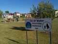
Park sign and climbing structure.
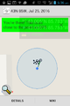
Proof.
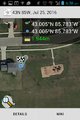
Proof at wider scale, showing house and playground.
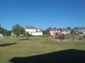
View E from hashpoint.

View W from hashpoint, showing grin.


