Difference between revisions of "2016-07-18 51 9"
From Geohashing
imported>GeorgDerReisende (new report) |
imported>GeorgDerReisende (expedition report for Wolfhagen-Viesebeck) |
||
| Line 1: | Line 1: | ||
| − | |||
| − | |||
| − | |||
| − | |||
| − | |||
| − | |||
| − | |||
| − | |||
| − | |||
| − | |||
{{meetup graticule | {{meetup graticule | ||
| lat=51 | | lat=51 | ||
| Line 19: | Line 9: | ||
== Location == | == Location == | ||
| − | + | ||
| + | In front of a house in Wolfhagen-Viesebeck. | ||
== Participants == | == Participants == | ||
| − | + | ||
| − | + | [[User:GeorgDerReisende|GeorgDerReisende]] | |
== Plans == | == Plans == | ||
| − | + | ||
| + | Again hitchhiking to Viesebeck. | ||
== Expedition == | == Expedition == | ||
| − | |||
| − | + | I hitchhiked from Kassel along Breuna and Volkmarsen to Lütersheim and walked the rest. The hash was in the foregarden of a house in Viesebeck, just five meters away from the street. Then I walked to Gasterfeld and found the national road from the west closed, but I got a lift to Kassel immediately. | |
| − | |||
== Photos == | == Photos == | ||
| − | |||
| − | |||
| − | |||
<gallery perrow="5"> | <gallery perrow="5"> | ||
| + | Image:2016-07-18 51 9 GeorgDerReisende 9056.jpg | The Wolfhager Straße to the nord, the hash on the left side. | ||
| + | Image:2016-07-18 51 9 GeorgDerReisende 9060.jpg | proof | ||
| + | Image:2016-07-18 51 9 GeorgDerReisende 9061.jpg | The hash is five meters on private ground. | ||
| + | Image:2016-07-18 51 9 GeorgDerReisende 9062.jpg | The opposite house. | ||
| + | Image:2016-07-18 51 9 GeorgDerReisende 9063.jpg | The Wolfhager Straße to the south. | ||
| + | Image:2016-07-18 51 9 GeorgDerReisende 9064.jpg | the geohasher | ||
| + | Image:2016-07-18 51 9 GeorgDerReisende 9176.jpg | closed national road | ||
</gallery> | </gallery> | ||
| Line 45: | Line 39: | ||
<!-- Add any achievement ribbons you earned below, or remove this section --> | <!-- Add any achievement ribbons you earned below, or remove this section --> | ||
| − | + | {{Thumbs Up | latitude = 51 | longitude = 9 | date = 2016-07-18 | name = GeorgDerReisende }} | |
| − | |||
| − | |||
| − | + | [[Category:Expeditions]] | |
| − | + | [[Category:Expeditions with photos]] | |
| − | |||
| − | |||
| − | |||
| − | |||
| − | |||
| − | |||
| − | |||
| − | |||
| − | |||
| − | |||
| − | |||
| − | |||
| − | |||
| − | |||
[[Category:Coordinates reached]] | [[Category:Coordinates reached]] | ||
| − | |||
| − | |||
| − | |||
| − | |||
| − | |||
| − | |||
| − | |||
| − | |||
| − | |||
| − | |||
| − | |||
| − | |||
| − | |||
| − | |||
| − | |||
| − | |||
| − | |||
| − | |||
Revision as of 20:50, 9 August 2016
| Mon 18 Jul 2016 in 51,9: 51.3543422, 9.1333489 geohashing.info google osm bing/os kml crox |
Location
In front of a house in Wolfhagen-Viesebeck.
Participants
Plans
Again hitchhiking to Viesebeck.
Expedition
I hitchhiked from Kassel along Breuna and Volkmarsen to Lütersheim and walked the rest. The hash was in the foregarden of a house in Viesebeck, just five meters away from the street. Then I walked to Gasterfeld and found the national road from the west closed, but I got a lift to Kassel immediately.
Photos
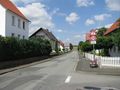
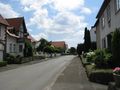
The Wolfhager Straße to the nord, the hash on the left side.
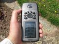
proof
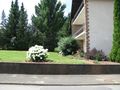
The hash is five meters on private ground.
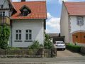
The opposite house.
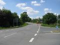
The Wolfhager Straße to the south.
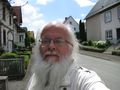
the geohasher
closed national road


Achievements
GeorgDerReisende earned the Thumbs Up Geohash Achievement
|