Difference between revisions of "2016-08-13 59 18"
From Geohashing
imported>Belteshassar (→Participants: Add Belteshassar) |
imported>Per S |
||
| Line 1: | Line 1: | ||
| + | {| width="100%" border=0 cellpadding=0 cellspacing=0 style="border: 0; border-collapse: collapse; border-spacing: 0; margin: 0; padding: 0" | ||
| − | + | | align="left" valign="top" style="padding: 0.5em 1em 0.5em 0" | [[Image:2016-08-13_59_18_05_The_Geohasher.jpg|467px]] | |
| − | + | | align="right" valign="top" | {{meetup graticule | |
| − | |||
| − | |||
| − | |||
| − | |||
| − | |||
| − | |||
| − | {{meetup graticule | ||
| lat=59 | | lat=59 | ||
| lon=18 | | lon=18 | ||
| date=2016-08-13 | | date=2016-08-13 | ||
| + | | graticule_name=Stockholm | ||
| + | | graticule_link=Stockholm, Sweden | ||
}} | }} | ||
| − | + | |} | |
| + | |||
__NOTOC__ | __NOTOC__ | ||
== Location == | == Location == | ||
| − | + | On the sidewalk near Kungsgatan 15 in central Stockholm. | |
== Participants == | == Participants == | ||
| − | + | * [[User:Belteshassar|Belteshassar]] | |
| − | + | * [[User:Per S|Per S]] | |
| − | |||
| − | [[User:Belteshassar|Belteshassar]] | ||
== Plans == | == Plans == | ||
| − | + | === Per S === | |
| + | To be there at 4:00 PM, the official Saturday meetup time. | ||
== Expedition == | == Expedition == | ||
| − | + | === Per S === | |
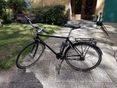
| − | + | I decided to take the bike and earn the bicycle geohash achievement. The hash was only about 5 km (3 miles) from home and the ride took about 20 minutes in nice, sunny weather. I arrived on time and hung around about 20 minutes, trying to get a decent GPS fix and taking a few pictures. | |
| − | + | It was a bit hard to get a good GPS fix, as [[User:Belteshassar|Belteshassar]] mentions below, but I think I found the hashpoint. | |
| − | |||
| − | |||
== Photos == | == Photos == | ||
| − | + | === Belteshassar === | |
| − | + | <gallery widths=117px perrow="5"> | |
| − | + | Image:2016-08-13_59_18_Belteshassar_1471083934670.jpg | GPS gets lost in urban environment, but I think this is the spot. No good Pokémon nearby unfortunately. [http://www.openstreetmap.org/?lat=59.33619680&lon=18.06910890&zoom=16&layers=B000FTF @59.3362,18.0691] | |
| − | <gallery perrow="5"> | + | </gallery> |
| − | + | === Per S === | |
| − | Image:2016-08-13_59_18_Belteshassar_1471083934670.jpg|GPS gets lost in urban environment, but I think this is the spot. No good Pokémon nearby unfortunately. [http://www.openstreetmap.org/?lat=59.33619680&lon=18.06910890&zoom=16&layers=B000FTF @59.3362,18.0691] | + | <gallery widths=117px perrow="5"> |
| + | Image:2016-08-13_59_18_01_Todays_Citation.jpg | Today's [[Citation Needed|Citation]] | ||
| + | Image:2016-08-13_59_18_02_Kungsgatan.jpg | Kungsgatan | ||
| + | Image:2016-08-13_59_18_03_The_Hashpoint.jpg | The Hashpoint | ||
| + | Image:2016-08-13_59_18_04_Coordinates_Reached.png | Coordinates Reached | ||
| + | Image:2016-08-13_59_18_05_The_Geohasher.jpg | The Geohasher | ||
</gallery> | </gallery> | ||
== Achievements == | == Achievements == | ||
| − | {{ | + | {{bicycle geohash |
| − | + | | latitude = 59 | |
| − | + | | longitude = 18 | |
| − | + | | date = 2016-08-13 | |
| − | + | | name = [[User:Per S|Per S]] | |
| − | [[ | + | | distance = 10 km (6 miles) |
| − | + | | bothways = true | |
| − | + | | image = 2016-08-13_59_18_01_Todays_Citation.jpg | |
| − | + | }} | |
| − | |||
| − | |||
| − | |||
| − | |||
| − | |||
| − | |||
| − | |||
[[Category:Expeditions]] | [[Category:Expeditions]] | ||
| − | |||
[[Category:Expeditions with photos]] | [[Category:Expeditions with photos]] | ||
| − | |||
| − | |||
| − | |||
| − | |||
| − | |||
[[Category:Coordinates reached]] | [[Category:Coordinates reached]] | ||
| − | |||
| − | |||
| − | |||
| − | |||
| − | |||
| − | |||
| − | |||
| − | |||
| − | |||
| − | |||
| − | |||
| − | |||
| − | |||
| − | |||
| − | |||
| − | |||
| − | |||
| − | |||
Revision as of 21:02, 13 August 2016

|
| ||||||
Location
On the sidewalk near Kungsgatan 15 in central Stockholm.
Participants
Plans
Per S
To be there at 4:00 PM, the official Saturday meetup time.
Expedition
Per S
I decided to take the bike and earn the bicycle geohash achievement. The hash was only about 5 km (3 miles) from home and the ride took about 20 minutes in nice, sunny weather. I arrived on time and hung around about 20 minutes, trying to get a decent GPS fix and taking a few pictures.
It was a bit hard to get a good GPS fix, as Belteshassar mentions below, but I think I found the hashpoint.
Photos
Belteshassar
GPS gets lost in urban environment, but I think this is the spot. No good Pokémon nearby unfortunately. @59.3362,18.0691

Per S
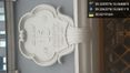
Today's Citation
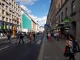
Kungsgatan

The Hashpoint
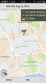
Coordinates Reached

The Geohasher


Achievements
Per S earned the Bicycle geohash achievement
|