Difference between revisions of "2016-10-20 51 9"
From Geohashing
imported>GeorgDerReisende (new report) |
imported>GeorgDerReisende (expedition report for Immenhausen) |
||
| Line 1: | Line 1: | ||
| − | |||
| − | |||
| − | |||
| − | |||
| − | |||
| − | |||
| − | |||
| − | |||
| − | |||
| − | |||
{{meetup graticule | {{meetup graticule | ||
| lat=51 | | lat=51 | ||
| Line 19: | Line 9: | ||
== Location == | == Location == | ||
| − | + | ||
| + | The hash lay on the edge of a field east of Immenhausen. | ||
== Participants == | == Participants == | ||
| − | + | ||
| − | + | [[User:GeorgDerReisende|GeorgDerReisende]] | |
== Plans == | == Plans == | ||
| − | + | ||
| + | Bus and tram and hitchhiking and walking. | ||
== Expedition == | == Expedition == | ||
| − | |||
| − | + | I started at 3 o'clock at home and started to hitchhike at 4 o'clock. The tenth car stopped and I got a lift to Immenhausen. I walked to the hash. I found it on the edge of the field. For a moment I had the zero meter view. Then I walked back to Immenhausen. On my way back to Kassel the second car stopped. | |
| − | |||
== Photos == | == Photos == | ||
| − | |||
| − | |||
| − | |||
<gallery perrow="5"> | <gallery perrow="5"> | ||
| + | Image:2016-10-20 51 9 GeorgDerReisende 8986.jpg | arrived in Immenhausen | ||
| + | Image:2016-10-20 51 9 GeorgDerReisende 9070.jpg | the second field is the field of hash | ||
| + | Image:2016-10-20 51 9 GeorgDerReisende 9071.jpg | fourty meters to hash | ||
| + | Image:2016-10-20 51 9 GeorgDerReisende 9073.jpg | for a moment | ||
| + | Image:2016-10-20 51 9 GeorgDerReisende 9076.jpg | view to the north | ||
| + | Image:2016-10-20 51 9 GeorgDerReisende 9074.jpg | to the east | ||
| + | Image:2016-10-20 51 9 GeorgDerReisende 9075.jpg | to the south | ||
| + | Image:2016-10-20 51 9 GeorgDerReisende 9077.jpg | to the west | ||
| + | Image:2016-10-20 51 9 GeorgDerReisende 9078.jpg | the geohasher | ||
</gallery> | </gallery> | ||
| Line 45: | Line 41: | ||
<!-- Add any achievement ribbons you earned below, or remove this section --> | <!-- Add any achievement ribbons you earned below, or remove this section --> | ||
| − | + | {{Thumbs Up | latitude = 51 | longitude = 9 | date = 2016-10-20 | name = GeorgDerReisende }} | |
| − | |||
| − | |||
| − | + | [[Category:Expeditions]] | |
| − | + | [[Category:Expeditions with photos]] | |
| − | |||
| − | |||
| − | |||
| − | |||
| − | |||
| − | |||
| − | |||
| − | |||
| − | |||
| − | |||
| − | |||
| − | |||
| − | |||
| − | |||
[[Category:Coordinates reached]] | [[Category:Coordinates reached]] | ||
| − | |||
| − | |||
| − | |||
| − | |||
| − | |||
| − | |||
| − | |||
| − | |||
| − | |||
| − | |||
| − | |||
| − | |||
| − | |||
| − | |||
| − | |||
| − | |||
| − | |||
| − | |||
Revision as of 18:50, 20 October 2016
| Thu 20 Oct 2016 in 51,9: 51.4239857, 9.5075865 geohashing.info google osm bing/os kml crox |
Location
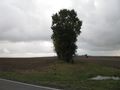
The hash lay on the edge of a field east of Immenhausen.
Participants
Plans
Bus and tram and hitchhiking and walking.
Expedition
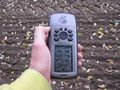
I started at 3 o'clock at home and started to hitchhike at 4 o'clock. The tenth car stopped and I got a lift to Immenhausen. I walked to the hash. I found it on the edge of the field. For a moment I had the zero meter view. Then I walked back to Immenhausen. On my way back to Kassel the second car stopped.
Photos
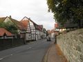
arrived in Immenhausen
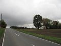
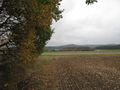
the second field is the field of hash
fourty meters to hash
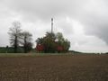
for a moment
view to the north
to the east
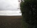
to the south
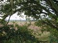
to the west
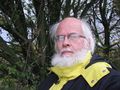
the geohasher


Achievements
GeorgDerReisende earned the Thumbs Up Geohash Achievement
|