Difference between revisions of "2017-01-23 47 8"
imported>ThreeFx (→Achievements) |
imported>ThreeFx (→Photos) |
||
| Line 48: | Line 48: | ||
Image:2017-01-23_47_8-proof.png | [[User:ThreeFx|ThreeFx]]'s almost empty phone with the coordinates. | Image:2017-01-23_47_8-proof.png | [[User:ThreeFx|ThreeFx]]'s almost empty phone with the coordinates. | ||
Image:2017-01-23_47_08-threefx.jpg | [[User:ThreeFx|ThreeFx]] at the hash. | Image:2017-01-23_47_08-threefx.jpg | [[User:ThreeFx|ThreeFx]] at the hash. | ||
| − | Image:2017-01-23_47_08-hash.jpg | | + | Image:2017-01-23_47_08-hash.jpg | The hash itself, located almost exactly on this street corner. |
| − | Image:2017-01-23_47_08-snowy.jpg | Switzerland's snowy landscape, passed | + | Image:2017-01-23_47_08-snowy.jpg | Switzerland's snowy landscape, passed en route to the hash. |
</gallery> | </gallery> | ||
Revision as of 17:15, 23 January 2017
| Mon 23 Jan 2017 in 47,8: 47.4163709, 8.5065222 geohashing.info google osm bing/os kml crox |
Location
Next to one of the main roads near Affoltern.
Participants
Plans
This was fairly spontaneous. At about 15:45 I decided to check today's hash and lo and behold, it's right next to the Hönggerberg, where a part of the ETH is located. 10 minutes later I was in the bus on my way to Höngg.
Expedition
The only thing I didn't check was my phone's battery, which was fairly empty already. But still, I arrived on the Hönggerberg at half past 4 and managed to walk straight down to the hash without my phone dying. After I took the photos, I walked back to the Hönggerberg without experiencing any difficulties - except the icy weather, against which I brought my jacket with me.
Tracklog
Photos
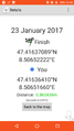
ThreeFx's almost empty phone with the coordinates.

ThreeFx at the hash.
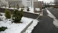
The hash itself, located almost exactly on this street corner.
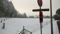
Switzerland's snowy landscape, passed en route to the hash.


Achievements