Difference between revisions of "2017-02-04 58 26"
imported>FelixTheCat (Created page with "{{subst:Expedition |lat = 58 |lon = 26 |date = 2017-02-04 }}") |
imported>FelixTheCat |
||
| Line 1: | Line 1: | ||
| − | |||
| − | |||
| − | |||
| − | |||
| − | |||
| − | |||
| − | |||
| − | |||
| − | |||
| − | |||
{{meetup graticule | {{meetup graticule | ||
| lat=58 | | lat=58 | ||
| Line 14: | Line 4: | ||
| date=2017-02-04 | | date=2017-02-04 | ||
}} | }} | ||
| − | |||
| − | |||
__NOTOC__ | __NOTOC__ | ||
== Location == | == Location == | ||
| − | + | On the edge of a field in Palupera Parish, Estonia. | |
== Participants == | == Participants == | ||
| − | + | [[User:FelixTheCat|FelixTheCat]] ([[User talk:FelixTheCat|talk]]) | |
| − | |||
| − | |||
| − | |||
| − | |||
== Expedition == | == Expedition == | ||
| − | + | I was on a trip in the Baltic states, and of course hoping for interesting geohashes to show up. This one seemed pretty doable so I decided to stop by on my way from Jekabpils (Latvia) to Tartu (Estonia). The navigation system in my rental hashmobile did a pretty good job of guiding me along country roads, and I arrived at the field around 15:20. I found a space to park on the edge of the field and proceeded to walk the last 500m or so to find the hash, among some trees and bushes. It took a bit of dancing to get a low enough reading (always tricky in wooded areas), but I managed to get within the accuracy and took some pictures. I quickly went back to the car because there were several menacing-sounding dogs barking quite loudly somewhere nearby and I didn't really fancy having to meet them. I set the satnav to Tartu and drove off again. | |
| − | |||
| − | |||
| − | |||
== Photos == | == Photos == | ||
| − | |||
| − | |||
| − | |||
<gallery perrow="5"> | <gallery perrow="5"> | ||
| + | Image:2017-02-04 58 26 FelixTheCat 1.JPG | The road towards the hash. | ||
| + | Image:2017-02-04 58 26 FelixTheCat 2.JPG | The hashfield. | ||
| + | Image:2017-02-04 58 26 FelixTheCat 3.JPG | It gets a bit snowier as we get closer to the point. | ||
| + | Image:2017-02-04 58 26 FelixTheCat 4.JPG | The point is here among the trees. | ||
| + | Image:2017-02-04 58 26 FelixTheCat 5.png | Made it! | ||
| + | Image:2017-02-04 58 26 FelixTheCat 6.JPG | Lloyd posing. | ||
| + | Image:2017-02-04 58 26 FelixTheCat 7.JPG | Proof of temperature. And of the fact that I almost made a Saturday meetup! | ||
</gallery> | </gallery> | ||
== Achievements == | == Achievements == | ||
{{#vardefine:ribbonwidth|800px}} | {{#vardefine:ribbonwidth|800px}} | ||
| − | + | {{Frozen Geohash | |
| − | + | | latitude = 58 | |
| − | + | | longitude = 26 | |
| − | + | | date = 2017-02-04 | |
| − | + | | temperature = -1.5 °C | |
| − | + | | name = [[User:FelixTheCat|FelixTheCat]] ([[User talk:FelixTheCat|talk]]) | |
| − | + | }} | |
| − | |||
| − | |||
| − | [[ | ||
| − | |||
| − | |||
| − | |||
| − | |||
| − | |||
[[Category:Expeditions]] | [[Category:Expeditions]] | ||
| − | |||
[[Category:Expeditions with photos]] | [[Category:Expeditions with photos]] | ||
| − | |||
| − | |||
| − | |||
| − | |||
| − | |||
[[Category:Coordinates reached]] | [[Category:Coordinates reached]] | ||
| − | |||
| − | |||
| − | |||
| − | |||
| − | |||
| − | |||
| − | |||
| − | |||
| − | |||
| − | |||
| − | |||
| − | |||
| − | |||
| − | |||
| − | |||
| − | |||
| − | |||
| − | |||
Revision as of 18:16, 6 February 2017
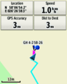
| Sat 4 Feb 2017 in 58,26: 58.1150716, 26.4439616 geohashing.info google osm bing/os kml crox |
Location
On the edge of a field in Palupera Parish, Estonia.
Participants
Expedition
I was on a trip in the Baltic states, and of course hoping for interesting geohashes to show up. This one seemed pretty doable so I decided to stop by on my way from Jekabpils (Latvia) to Tartu (Estonia). The navigation system in my rental hashmobile did a pretty good job of guiding me along country roads, and I arrived at the field around 15:20. I found a space to park on the edge of the field and proceeded to walk the last 500m or so to find the hash, among some trees and bushes. It took a bit of dancing to get a low enough reading (always tricky in wooded areas), but I managed to get within the accuracy and took some pictures. I quickly went back to the car because there were several menacing-sounding dogs barking quite loudly somewhere nearby and I didn't really fancy having to meet them. I set the satnav to Tartu and drove off again.
Photos
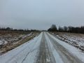
The road towards the hash.
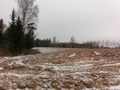
The hashfield.
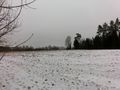
It gets a bit snowier as we get closer to the point.
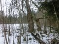
The point is here among the trees.
Made it!
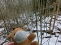
Lloyd posing.

Proof of temperature. And of the fact that I almost made a Saturday meetup!


Achievements
