Difference between revisions of "2017-02-05 57 24"
imported>FelixTheCat (Created page with "{{subst:Expedition |lat = 57 |lon = 24 |date = 2017-02-05 }}") |
imported>FelixTheCat |
||
| Line 1: | Line 1: | ||
| − | |||
| − | |||
| − | |||
| − | |||
| − | |||
| − | |||
| − | |||
| − | |||
| − | |||
| − | |||
{{meetup graticule | {{meetup graticule | ||
| lat=57 | | lat=57 | ||
| Line 14: | Line 4: | ||
| date=2017-02-05 | | date=2017-02-05 | ||
}} | }} | ||
| − | |||
| − | |||
__NOTOC__ | __NOTOC__ | ||
| − | |||
== Location == | == Location == | ||
| − | + | On the edge of Daugavgrīva fortress, Riga, Latvia. | |
== Participants == | == Participants == | ||
| − | + | [[User:FelixTheCat|FelixTheCat]] ([[User talk:FelixTheCat|talk]]) | |
| − | |||
| − | |||
| − | |||
| − | |||
== Expedition == | == Expedition == | ||
| − | + | I was on my way back from Tartu this Sunday, driving towards Riga Airport to catch my flight home. This hash was located on the northern edge of Riga, actually quite close to the airport. And it appeared to be on some old defensive location with bastions and such. Turns out this was an old fortress that was used to defend the mouth of the river Daugava, but which is nowadays open to the public. A few other people were wandering around in the area. The fortress looks derelict and abandoned, and has quite an "urbexy" feel to it. I walked up to one of the bastions and found that the hash was 64 metres ahead of me, right down by the water. Not sure if I would be able to reach that point I walked around to the other side, and discovered that there was in fact a passage all the way down. The point was really on the edge of the water, but because it was frozen I could step just a bit further than I would have done in summer (although the ice was really not strong enough to stand on). I took a few pictures, wandered around a bit more and then went on to the airport. | |
| − | + | This was a really nice and unique location that I would never have visited otherwise :-) | |
| − | |||
| − | == Photos == | + | == Photos == |
| − | |||
| − | |||
| − | |||
<gallery perrow="5"> | <gallery perrow="5"> | ||
| + | Image:2017-02-05 57 24 FelixTheCat 1.JPG | Inside the fortress there are a few signs explaining its history. Only in Latvian unfortunately. | ||
| + | Image:2017-02-05 57 24 FelixTheCat 2.JPG | The walls are made of bricks and look pretty nice. | ||
| + | Image:2017-02-05 57 24 FelixTheCat 3.JPG | The insides however show the result of many years of use and neglect. | ||
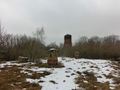
| + | Image:2017-02-05 57 24 FelixTheCat 4.JPG | There's a huge tower in the middle with a wooden section on top. It too has seen better days. | ||
| + | Image:2017-02-05 57 24 FelixTheCat 5.JPG | Smaller towers are located on top of the bastions. | ||
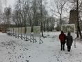
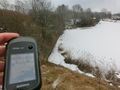
| + | Image:2017-02-05 57 24 FelixTheCat 6.JPG | The hash is 64m ahead. Doesn't look good from here... | ||
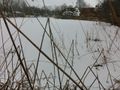
| + | Image:2017-02-05 57 24 FelixTheCat 7.JPG | But down here it looks all right! | ||
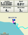
| + | Image:2017-02-05 57 24 FelixTheCat 8.png | Made it! | ||
| + | Image:2017-02-05 57 24 FelixTheCat 9.JPG | Lloyd is happy with another successful expedition. | ||
</gallery> | </gallery> | ||
== Achievements == | == Achievements == | ||
{{#vardefine:ribbonwidth|800px}} | {{#vardefine:ribbonwidth|800px}} | ||
| − | + | {{land geohash | |
| − | + | | latitude = 57 | |
| − | + | | longitude = 24 | |
| − | + | | date = 2017-02-05 | |
| − | + | | name = [[User:FelixTheCat|FelixTheCat]] ([[User talk:FelixTheCat|talk]]) | |
| − | + | }} | |
| − | |||
| − | |||
| − | |||
| − | |||
| − | |||
| − | |||
| − | |||
| − | |||
| − | |||
| − | |||
[[Category:Expeditions]] | [[Category:Expeditions]] | ||
| − | |||
[[Category:Expeditions with photos]] | [[Category:Expeditions with photos]] | ||
| − | |||
| − | |||
| − | |||
| − | |||
| − | |||
[[Category:Coordinates reached]] | [[Category:Coordinates reached]] | ||
| − | |||
| − | |||
| − | |||
| − | |||
| − | |||
| − | |||
| − | |||
| − | |||
| − | |||
| − | |||
| − | |||
| − | |||
| − | |||
| − | |||
| − | |||
| − | |||
| − | |||
| − | |||
Revision as of 22:27, 6 February 2017
| Sun 5 Feb 2017 in 57,24: 57.0435171, 24.0398548 geohashing.info google osm bing/os kml crox |
Location
On the edge of Daugavgrīva fortress, Riga, Latvia.
Participants
Expedition
I was on my way back from Tartu this Sunday, driving towards Riga Airport to catch my flight home. This hash was located on the northern edge of Riga, actually quite close to the airport. And it appeared to be on some old defensive location with bastions and such. Turns out this was an old fortress that was used to defend the mouth of the river Daugava, but which is nowadays open to the public. A few other people were wandering around in the area. The fortress looks derelict and abandoned, and has quite an "urbexy" feel to it. I walked up to one of the bastions and found that the hash was 64 metres ahead of me, right down by the water. Not sure if I would be able to reach that point I walked around to the other side, and discovered that there was in fact a passage all the way down. The point was really on the edge of the water, but because it was frozen I could step just a bit further than I would have done in summer (although the ice was really not strong enough to stand on). I took a few pictures, wandered around a bit more and then went on to the airport.
This was a really nice and unique location that I would never have visited otherwise :-)
Photos
Inside the fortress there are a few signs explaining its history. Only in Latvian unfortunately.
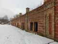
The walls are made of bricks and look pretty nice.
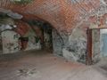
The insides however show the result of many years of use and neglect.
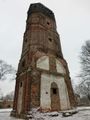
There's a huge tower in the middle with a wooden section on top. It too has seen better days.
Smaller towers are located on top of the bastions.
The hash is 64m ahead. Doesn't look good from here...
But down here it looks all right!
Made it!
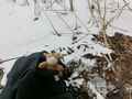
Lloyd is happy with another successful expedition.


Achievements
FelixTheCat (talk) earned the Land geohash achievement
|