Difference between revisions of "2017-03-08 47 -122"
From Geohashing
imported>Zebburkeconte (→Photos) |
imported>Zebburkeconte (→Achievements) |
||
| Line 75: | Line 75: | ||
{{#vardefine:ribbonwidth|800px}} | {{#vardefine:ribbonwidth|800px}} | ||
<!-- Add any achievement ribbons you earned below, or remove this section --> | <!-- Add any achievement ribbons you earned below, or remove this section --> | ||
| + | |||
| + | {{Walk geohash | ||
| + | | latitude = 47 | ||
| + | | longitude = -122 | ||
| + | | date = 2017-03-08 | ||
| + | | name = Zeb & Dillon | ||
| + | | distance = 1.7 miles | ||
| + | }} | ||
<!-- =============== USEFUL CATEGORIES FOLLOW ================ | <!-- =============== USEFUL CATEGORIES FOLLOW ================ | ||
Revision as of 22:49, 9 March 2017
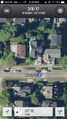
| Wed 8 Mar 2017 in 47,-122: 47.6576468, -122.2771632 geohashing.info google osm bing/os kml crox |
Location
Just off the sidewalk in a Laurelhurst street.
Participants
- Zebburkeconte and
- friend Dillon of 2015-11-15 47 -122 fame
Plans
Expedition
- Here -- Thomcat (talk) @47.6577,-122.2772 22:33, 8 March 2017 (PST)
zebburkeconte
Finally, a walk geohash opportunity! I had taken a bus from home, but between when I saw the geohash (on campus) and reached it, it was walking-only, so I'm going to count it. Probably could have tronned it if we tried, but we didn't.
Tracklog
Photos
Thomcat
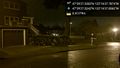
On the spot @47.6576,-122.2772

Geohasher @47.6577,-122.2772


zebburkeconte
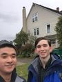
Cheesin'
Proof


Achievements
Zeb & Dillon earned the Walk geohash Achievement
|