Difference between revisions of "2017-03-25 51 3"
imported>FelixTheCat (Created page with "{{subst:Expedition |lat = 51 |lon = 3 |date = 2017-03-25 }}") |
imported>FelixTheCat |
||
| Line 1: | Line 1: | ||
| − | |||
| − | |||
| − | |||
| − | |||
| − | |||
| − | |||
| − | |||
| − | |||
| − | |||
| − | |||
{{meetup graticule | {{meetup graticule | ||
| lat=51 | | lat=51 | ||
| Line 14: | Line 4: | ||
| date=2017-03-25 | | date=2017-03-25 | ||
}} | }} | ||
| − | |||
| − | |||
__NOTOC__ | __NOTOC__ | ||
== Location == | == Location == | ||
| − | + | On a tidal mudflat at Kattendijke, Zeeland Province, the Netherlands. | |
== Participants == | == Participants == | ||
| − | + | [[User:FelixTheCat|FelixTheCat]] ([[User talk:FelixTheCat|talk]]) | |
| − | |||
| − | |||
| − | |||
| − | |||
== Expedition == | == Expedition == | ||
| − | + | Today's hash was at a very interesting location: a tidal mudflat, which is a relatively common type of wetland on the Dutch coast. These are muddy areas that are completely submerged at high tide, but fall dry at low tide. So to make sure I could actually walk to the hash I consulted a tide calculator the day before, and determined that I had to visit before noon. So I got up early, drove to Zeeland and parked at the coast outside the village of Kattendijke. The mudflat looked accessible, and there were in fact several people walking on it. They were digging into the mud, which means they were likely searching for sandworms to be used as fishing bait. | |
| − | + | I walked onto the mud as well, and luckily it was just solid enough to support my weight without me sinking more than a cm or so (I was in my regular hiking shoes, not in wellingtons like the digging people). I walked towards the hash, got a zero reading on the GPS and took some pictures. I then walked a bit more around the surrounding areas, enjoying the fresh sea breeze, and then went back to the car. I went on to visit a few museums in Vlissingen and Zierikzee, and then went home. | |
| − | |||
== Photos == | == Photos == | ||
| − | |||
| − | |||
| − | |||
<gallery perrow="5"> | <gallery perrow="5"> | ||
| + | Image:2017-03-25 51 3 FelixTheCat 1.JPG | Looking out over the mudflat from the dyke. | ||
| + | Image:2017-03-25 51 3 FelixTheCat 2.JPG | Getting a bit closer. Someone's digging into the mud. | ||
| + | Image:2017-03-25 51 3 FelixTheCat 3.JPG | Looking back onto the dyke and the village. | ||
| + | Image:2017-03-25 51 3 FelixTheCat 4.JPG | Standing on the hashpoint. Lloyd posing as well. | ||
| + | Image:2017-03-25 51 3 FelixTheCat 5.png | We made it! Looks weird like this, 180m from the coast... | ||
| + | Image:2017-03-25 51 3 FelixTheCat 6.JPG | Up close, it really looks like we're standing on the bottom of the sea (because we are). | ||
| + | Image:2017-03-25 51 3 FelixTheCat 7.JPG | There's actually some vegetation here. | ||
| + | Image:2017-03-25 51 3 FelixTheCat 8.JPG | Standing on the dyke again. On the right is the mudflat, on the left is a worm farm. Here they grow sandworms (''Alitta virens'') to be used as feed in fish farms or as bait for anglers (like those people digging in the mud). | ||
</gallery> | </gallery> | ||
| − | |||
| − | |||
| − | |||
| − | |||
| − | |||
| − | |||
| − | |||
| − | |||
| − | |||
| − | |||
| − | |||
| − | |||
| − | |||
| − | |||
| − | |||
| − | |||
| − | |||
| − | |||
| − | |||
[[Category:Expeditions]] | [[Category:Expeditions]] | ||
| − | |||
[[Category:Expeditions with photos]] | [[Category:Expeditions with photos]] | ||
| − | |||
| − | |||
| − | |||
| − | |||
| − | |||
[[Category:Coordinates reached]] | [[Category:Coordinates reached]] | ||
| − | |||
| − | |||
| − | |||
| − | |||
| − | |||
| − | |||
| − | |||
| − | |||
| − | |||
| − | |||
| − | |||
| − | |||
| − | |||
| − | |||
| − | |||
| − | |||
| − | |||
| − | |||
Revision as of 23:20, 25 March 2017
| Sat 25 Mar 2017 in 51,3: 51.5297083, 3.9380789 geohashing.info google osm bing/os kml crox |
Location
On a tidal mudflat at Kattendijke, Zeeland Province, the Netherlands.
Participants
Expedition
Today's hash was at a very interesting location: a tidal mudflat, which is a relatively common type of wetland on the Dutch coast. These are muddy areas that are completely submerged at high tide, but fall dry at low tide. So to make sure I could actually walk to the hash I consulted a tide calculator the day before, and determined that I had to visit before noon. So I got up early, drove to Zeeland and parked at the coast outside the village of Kattendijke. The mudflat looked accessible, and there were in fact several people walking on it. They were digging into the mud, which means they were likely searching for sandworms to be used as fishing bait.
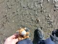
I walked onto the mud as well, and luckily it was just solid enough to support my weight without me sinking more than a cm or so (I was in my regular hiking shoes, not in wellingtons like the digging people). I walked towards the hash, got a zero reading on the GPS and took some pictures. I then walked a bit more around the surrounding areas, enjoying the fresh sea breeze, and then went back to the car. I went on to visit a few museums in Vlissingen and Zierikzee, and then went home.
Photos
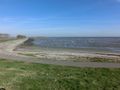
Looking out over the mudflat from the dyke.
Getting a bit closer. Someone's digging into the mud.
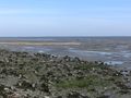
Looking back onto the dyke and the village.
Standing on the hashpoint. Lloyd posing as well.
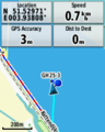
We made it! Looks weird like this, 180m from the coast...
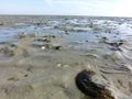
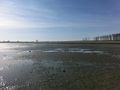
Up close, it really looks like we're standing on the bottom of the sea (because we are).
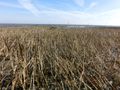
There's actually some vegetation here.
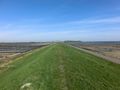
Standing on the dyke again. On the right is the mudflat, on the left is a worm farm. Here they grow sandworms (Alitta virens) to be used as feed in fish farms or as bait for anglers (like those people digging in the mud).


