Difference between revisions of "2017-04-22 49 9"
imported>Uvok (Added images) |
imported>Fippe m (This page has already been categorised, so I removed category:new report.) |
||
| Line 51: | Line 51: | ||
<!-- =============== USEFUL CATEGORIES FOLLOW ================ | <!-- =============== USEFUL CATEGORIES FOLLOW ================ | ||
Delete the next line ONLY if you have chosen the appropriate categories below. If you are unsure, don't worry. People will read your report and help you with the classification. --> | Delete the next line ONLY if you have chosen the appropriate categories below. If you are unsure, don't worry. People will read your report and help you with the classification. --> | ||
| − | |||
[[Category:Expeditions]] | [[Category:Expeditions]] | ||
[[Category:Expeditions with photos]] | [[Category:Expeditions with photos]] | ||
[[Category:Coordinates reached]] | [[Category:Coordinates reached]] | ||
Revision as of 10:49, 25 July 2019
| Sat 22 Apr 2017 in 49,9: 49.5860648, 9.8207514 geohashing.info google osm bing/os kml crox |
Location
GeoHashDroid showed me a location near me, so I decided to give it a go. The location was on a field near the small village of Vilchband.
Participants
Plans
Had no plans, it was a rather spontaneous idea.
Expedition
It was nearly 5 p.m. when I arrived, but still light. Turned out Vilchband was bigger than expected. Also, I had no network on the street.
I had to walk upward for a bit to approach the geohash point. It was rather windy and unpleasent. As it turned out, I could only approach the point up to 50 meters, since it was in the middle of a field and I didn't want to step on it.
Photos
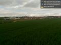
Went to a field near Vilchband. It was really windy. (Ignore distance, uploaded from home)
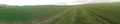
A panorama recorded from near the geohash point
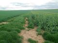
How far I could approach
A single tree in the distance


