Difference between revisions of "2017-05-27 49 8"
imported>DODO (→Plans) |
imported>DODO |
||
| Line 33: | Line 33: | ||
== Expedition == | == Expedition == | ||
<!-- how it all turned out. your narrative goes here. --> | <!-- how it all turned out. your narrative goes here. --> | ||
| + | We started a little late but ride quickly to Lingenfeld. I left the ldy there and continued my ride to Germersheim (the third time in one week). This time, I crossed the Rhine on the bridge in Germersheim and continued my ride through the fields and forests. Exactly at 4 o'clock I reached Obergrombach. Just 3 more kilometers to go. What cn go wrong now? Well, the answer is easy. The road goes up for the next theree kilometers and time runs away. When I reached the top of the mountain I was totally exhausted. There on the left is the path that leads to the hash. Two people standing there, talking. Maybe I'm not the only hasher today? Well, I guess, most hashers would have recogniced me (or my behaviour) instead of just waving their good byes and leave. But at 16:14 I reached the hash, just within the academic quarter that I grant myself for the saturday meetup time. I did rest 2 or 3 minutes then I continued my ride. But it was still refreshing as it goes downwards now. Fifteen minutes later I reached the station in Bruchsal. Is that my train over there at track five? Oh yes, it is, and it'll leave in 4 minutes. Just enough time, to buy a ticket and carry my bike there (I was so happy that I didn#t have to carry my bull up and down the stairs). I reached home in less than an hour at 17:30. | ||
== Tracklog == | == Tracklog == | ||
<!-- if your GPS device keeps a log, you may post a link here --> | <!-- if your GPS device keeps a log, you may post a link here --> | ||
| + | [https://www.komoot.de/tour/17195474 54 KM by bike and 37 KM by train] | ||
== Photos == | == Photos == | ||
| Line 41: | Line 43: | ||
Image:2012-##-## ## ## Alpha.jpg | Witty Comment | Image:2012-##-## ## ## Alpha.jpg | Witty Comment | ||
--> | --> | ||
| − | <gallery perrow=" | + | <gallery perrow="4"> |
| + | Image:2017-05-27 49 8-1.jpg|bike (proof of transport) | ||
| + | Image:2017-05-27 49 8-7.png|proof | ||
| + | Image:2017-05-27 49 8-2.jpg|view downwards (to the east) | ||
| + | Image:2017-05-27 49 8-3.jpg|the north | ||
| + | Image:2017-05-27 49 8-4.jpg|the bike (in the south) | ||
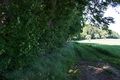
| + | Image:2017-05-27 49 8-5.jpg|another path into the forest in the west | ||
| + | Image:2017-05-27 49 8-6.jpg|and an exhausted but happy hasher | ||
</gallery> | </gallery> | ||
== Achievements == | == Achievements == | ||
{{#vardefine:ribbonwidth|800px}} | {{#vardefine:ribbonwidth|800px}} | ||
| − | + | {{land geohash | |
| + | | latitude = 49 | ||
| + | | longitude = 8 | ||
| + | | date = 2017-05-27 | ||
| + | | name = DODO | ||
| + | }} | ||
| − | + | {{consecutive geohash | |
| − | + | | count = 3 | |
| − | + | | latitude = 49 | |
| + | | longitude = 8 | ||
| + | | date = 2017-05-25 | ||
| + | | name = DODO | ||
| + | }} | ||
| − | + | {{bicycle geohash | |
| + | | latitude = 49 | ||
| + | | longitude = 8 | ||
| + | | date = 2017-05-27 | ||
| + | | name = DODO | ||
| + | | distance = 54 KM | ||
| + | }} | ||
| − | + | {{Geohashing Day | |
| − | |||
| − | |||
| − | |||
| − | + | | latitude = 49 | |
| + | | longitude = 8 | ||
| + | | year = 2017 | ||
| + | | coorddate= 2017-05-27 | ||
| + | | mouseover = true | ||
| + | | name = DODO | ||
| + | }} | ||
| − | |||
[[Category:Expeditions]] | [[Category:Expeditions]] | ||
| − | + | ||
| − | |||
| − | |||
| − | |||
| − | |||
| − | |||
| − | |||
[[Category:Coordinates reached]] | [[Category:Coordinates reached]] | ||
| − | |||
| − | |||
| − | |||
| − | |||
| − | |||
| − | |||
| − | |||
| − | |||
| − | |||
| − | |||
| − | |||
| − | |||
| − | |||
| − | |||
| − | |||
| − | |||
| − | |||
| − | |||
Revision as of 17:11, 27 May 2017
| Sat 27 May 2017 in 49,8: 49.0833830, 8.6098501 geohashing.info google osm bing/os kml crox |
Location
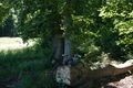
Forest between Obergrombach and Helmsheim.
Participants
Plans
Go there by bike. The lady has to go to Lingenfeld at 13:45 and I will accompany her. I try to be there at hash o'clock but maybe I'll be a little late.
Expedition
We started a little late but ride quickly to Lingenfeld. I left the ldy there and continued my ride to Germersheim (the third time in one week). This time, I crossed the Rhine on the bridge in Germersheim and continued my ride through the fields and forests. Exactly at 4 o'clock I reached Obergrombach. Just 3 more kilometers to go. What cn go wrong now? Well, the answer is easy. The road goes up for the next theree kilometers and time runs away. When I reached the top of the mountain I was totally exhausted. There on the left is the path that leads to the hash. Two people standing there, talking. Maybe I'm not the only hasher today? Well, I guess, most hashers would have recogniced me (or my behaviour) instead of just waving their good byes and leave. But at 16:14 I reached the hash, just within the academic quarter that I grant myself for the saturday meetup time. I did rest 2 or 3 minutes then I continued my ride. But it was still refreshing as it goes downwards now. Fifteen minutes later I reached the station in Bruchsal. Is that my train over there at track five? Oh yes, it is, and it'll leave in 4 minutes. Just enough time, to buy a ticket and carry my bike there (I was so happy that I didn#t have to carry my bull up and down the stairs). I reached home in less than an hour at 17:30.
Tracklog
54 KM by bike and 37 KM by train
Photos
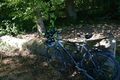
bike (proof of transport)
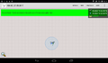
proof
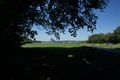
view downwards (to the east)
the north
the bike (in the south)
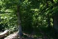
another path into the forest in the west

and an exhausted but happy hasher


Achievements
DODO earned the Land geohash achievement
|
DODO earned the Consecutive geohash achievement
|
DODO earned the Bicycle geohash achievement
|
DODO earned the 2017 Mouse Over Day achievement
|