Difference between revisions of "2017-06-16 42 -78"
imported>Pedalpusher (new expedition report) |
imported>FippeBot m (Location) |
||
| Line 30: | Line 30: | ||
[[Category:Coordinates reached]] | [[Category:Coordinates reached]] | ||
[[Category:Expeditions with photos]] | [[Category:Expeditions with photos]] | ||
| + | {{location|US|NY|ER}} | ||
Revision as of 02:38, 16 August 2019
| Fri 16 Jun 2017 in 42,-78: 42.9908856, -78.9623707 geohashing.info google osm bing/os kml crox |
Location
Edge of Sheree Rd. on Grand Island
Participants
Expedition
Saw this while still at work and I could have taken a long lunch to get it then, but that would mean I would have to stay later. That of course means I hit the worst of rush hour so I decided to go in the evening. Getting home, I checked the Buffalo Slow Roll page and there was a practice ride at 18:30 so I could participate there and not just drive a half hour for a hash. We are starting downtown this week at the Buffalo News and exploring the East and West sides a bit after going through downtown. After the ride, we had a post-ride beer and some food at the Expo Market. Very good, but my burrito was a bit more spicy that I was expecting.
Getting to be 21:00, we went our separate ways, with me heading further north to Grand Island. Being lazy after work, I didn't write down directions so I used Google maps as my GPS Navigator and made it to the hash very easily after paying my $1 toll to get on the island. As I neared the hash, I thought I passed it while I was parking and was thinking I would have to walk back a house. Would have been kind of awkward as that driveway had a bunch of older kids having a fire in the driveway. However, when the GPS settled on the HashDroid, I had parked right at the hash. It was a little jumpy, but I got a good reading and a few dark pictures. A simple expedition, successfully executed and I was on my way home.
Photos
Made it.
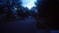
View West down the road from the hash.
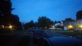
View East, the direction I arrived, from the hash.

Bad lighting with it getting dark, but I'm happy to make it.


Ribbons
This user earned the Land geohash achievement
|