Difference between revisions of "2017-06-28 48 9"
imported>Klaus (template) |
imported>Klaus (expedition report) |
||
| Line 1: | Line 1: | ||
| + | [[Image:{{{image|2017-06-28 121919 view geohash 5.jpg}}}|thumb|left]] | ||
| − | |||
| − | |||
| − | |||
| − | |||
| − | |||
| − | |||
| − | |||
| − | |||
| − | |||
{{meetup graticule | {{meetup graticule | ||
| lat=48 | | lat=48 | ||
| Line 14: | Line 6: | ||
| date=2017-06-28 | | date=2017-06-28 | ||
}} | }} | ||
| − | |||
| − | |||
| − | |||
== Location == | == Location == | ||
| − | + | Stuetzlesweg/Bohnackerstrasse, Echterdingen, Germany | |
== Participants == | == Participants == | ||
| − | + | * [[User:Klaus|Klaus]] | |
| − | |||
== Plans == | == Plans == | ||
| − | + | I noticed in the morning, that this hash is less than 1km from where I'm staying at the moment. | |
| + | As I have a day off, too, this should be very easy. | ||
== Expedition == | == Expedition == | ||
| − | |||
| − | + | I started walking at around 11:50. | |
| − | + | As the whole walking distance back and forth was less than 2km, I decided to walk a few hundreds meters more and to visit the [https://de.wikipedia.org/wiki/Zeppelinstein#Zeppelinstein_in_Echterdingen "Zeppelin-Stone"]. | |
| + | |||
| + | In 1908, a zeppelin had to do an emergency landing there because of a motor defect. | ||
| + | Ten thousands of people came to visit the zeppelin, however in the afternoon a thunderstorm teared the ropes apart, the zeppelin drifted away and exploded, after the hydrogen was ignited by static electricity. | ||
| + | This was bad luck for Zeppelin, who wanted to demonstrate the capabilities of zeppelins. | ||
| + | However there was a lot of sympathy of the people and they raised 6.5 million goldmark to build new zeppelins. | ||
| + | This was the short version, for more details you can read [https://de.wikipedia.org/wiki/Zeppelinspende_des_deutschen_Volkes the German Wikipedia]. | ||
| + | |||
| + | The geohash itself was easily reachable near on the small street Stuetzlesweg. | ||
| + | At 12:18 (after visiting the zeppelin stone), I reached it and walked back home where I arrived at around 12:30. | ||
== Photos == | == Photos == | ||
| − | |||
| − | |||
| − | |||
<gallery perrow="5"> | <gallery perrow="5"> | ||
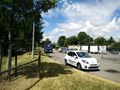
| + | Image:2017-06-28 120929 Zeppelinstein Schild.jpg | Zeppelin-Stone Explanation Sign | ||
| + | Image:2017-06-28 121143 Zeppelinstein.jpg | Zeppelin-Stone | ||
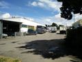
| + | Image:2017-06-28_48_9_proof.png | proof | ||
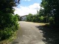
| + | Image:2017-06-28 121844 view geohash 1.jpg | View from hash #1 | ||
| + | Image:2017-06-28 121846 view geohash 2.jpg | View from hash #2 | ||
| + | Image:2017-06-28 121859 view geohash 3.jpg | View from hash #3 | ||
| + | Image:2017-06-28 121901 view geohash 4.jpg | View from hash #4 | ||
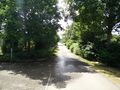
| + | Image:2017-06-28 121919 view geohash 5.jpg | View from hash #5 | ||
</gallery> | </gallery> | ||
== Achievements == | == Achievements == | ||
{{#vardefine:ribbonwidth|800px}} | {{#vardefine:ribbonwidth|800px}} | ||
| − | |||
| − | + | {{land geohash | |
| − | + | | latitude = 48 | |
| − | [[ | + | | longitude = 8 |
| + | | date = 2017-06-28 | ||
| + | | name = [[User:Klaus|Klaus]] | ||
| + | }} | ||
| − | + | {{Walk geohash | |
| + | | latitude = 48 | ||
| + | | longitude = 9 | ||
| + | | date = 2017-06-28 | ||
| + | | name = [[User:Klaus|Klaus]] | ||
| + | }} | ||
| − | |||
| − | |||
| − | |||
| − | |||
| − | |||
| − | |||
[[Category:Expeditions]] | [[Category:Expeditions]] | ||
| − | |||
[[Category:Expeditions with photos]] | [[Category:Expeditions with photos]] | ||
| − | |||
| − | |||
| − | |||
| − | |||
| − | |||
[[Category:Coordinates reached]] | [[Category:Coordinates reached]] | ||
| − | |||
| − | |||
| − | |||
| − | |||
| − | |||
| − | |||
| − | |||
| − | |||
| − | |||
| − | |||
| − | |||
| − | |||
| − | |||
| − | |||
| − | |||
| − | |||
| − | |||
| − | |||
Revision as of 12:49, 28 June 2017

| Wed 28 Jun 2017 in 48,9: 48.6847823, 9.1759589 geohashing.info google osm bing/os kml crox |
Location
Stuetzlesweg/Bohnackerstrasse, Echterdingen, Germany
Participants
Plans
I noticed in the morning, that this hash is less than 1km from where I'm staying at the moment. As I have a day off, too, this should be very easy.
Expedition
I started walking at around 11:50. As the whole walking distance back and forth was less than 2km, I decided to walk a few hundreds meters more and to visit the "Zeppelin-Stone".
In 1908, a zeppelin had to do an emergency landing there because of a motor defect. Ten thousands of people came to visit the zeppelin, however in the afternoon a thunderstorm teared the ropes apart, the zeppelin drifted away and exploded, after the hydrogen was ignited by static electricity. This was bad luck for Zeppelin, who wanted to demonstrate the capabilities of zeppelins. However there was a lot of sympathy of the people and they raised 6.5 million goldmark to build new zeppelins. This was the short version, for more details you can read the German Wikipedia.
The geohash itself was easily reachable near on the small street Stuetzlesweg. At 12:18 (after visiting the zeppelin stone), I reached it and walked back home where I arrived at around 12:30.
Photos
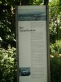
Zeppelin-Stone Explanation Sign
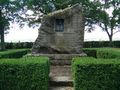
Zeppelin-Stone
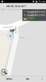
proof
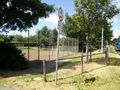
View from hash #1
View from hash #2
View from hash #3
View from hash #4
View from hash #5


Achievements
Klaus earned the Land geohash achievement
|
Klaus earned the Walk geohash Achievement
|