Difference between revisions of "2017-07-20 51 9"
imported>GeorgDerReisende (new report) |
imported>GeorgDerReisende (expedition report for Calden) |
||
| Line 1: | Line 1: | ||
| − | |||
| − | |||
| − | |||
| − | |||
| − | |||
| − | |||
| − | |||
| − | |||
| − | |||
| − | |||
{{meetup graticule | {{meetup graticule | ||
| lat=51 | | lat=51 | ||
| Line 19: | Line 9: | ||
== Location == | == Location == | ||
| − | + | ||
| + | The hash lay on a meadow near Calden. | ||
== Participants == | == Participants == | ||
| − | + | ||
| − | + | [[User:GeorgDerReisende|GeorgDerReisende]] | |
== Plans == | == Plans == | ||
| − | + | ||
| + | Today I wanted to take the bus. | ||
== Expedition == | == Expedition == | ||
| − | |||
| − | + | I left home at 13:40, and the transport planner told me an arrival time at Wilhelmsthal one hour later. But there was a tram failure in the city and the regiotram to Espenau got a delay of ten minutes, which was enough to miss the bus there. So I waited nearly one hour for the next one. From Wilhelmsthal I walked on. The last weeks I had two geohashes with already crop on the field and today I wanted only to see the field. To my astonishment there was no field but a meadow. Good luck! The hash was 30 meters away from the field way. No need for a dance. A little bit rain. Some sun. Fun. | |
| − | |||
== Photos == | == Photos == | ||
| − | |||
| − | |||
| − | |||
<gallery perrow="5"> | <gallery perrow="5"> | ||
| + | Image:2017-07-20 51 9 GeorgDerReisende 8122.jpg | a meadow! | ||
| + | Image:2017-07-20 51 9 GeorgDerReisende 8134.jpg | 30 meters to hash | ||
| + | Image:2017-07-20 51 9 GeorgDerReisende 8135.jpg | proof | ||
| + | Image:2017-07-20 51 9 GeorgDerReisende 8144.jpg | the geohasher | ||
| + | Image:2017-07-20 51 9 GeorgDerReisende 8145.jpg | the east | ||
| + | Image:2017-07-20 51 9 GeorgDerReisende 8146.jpg | the south | ||
| + | Image:2017-07-20 51 9 GeorgDerReisende 8147.jpg | the west | ||
| + | Image:2017-07-20 51 9 GeorgDerReisende 8148.jpg | the north | ||
| + | Image:2017-07-20 51 9 GeorgDerReisende 8149.jpg | a guest | ||
</gallery> | </gallery> | ||
| Line 45: | Line 41: | ||
<!-- Add any achievement ribbons you earned below, or remove this section --> | <!-- Add any achievement ribbons you earned below, or remove this section --> | ||
| − | + | {{land geohash | latitude = 51 | longitude = 9 | date = 2017-07-20 | name = GeorgDerReisende }} | |
| − | |||
| − | |||
| − | + | [[Category:Expeditions]] | |
| − | + | [[Category:Expeditions with photos]] | |
| − | |||
| − | |||
| − | |||
| − | |||
| − | |||
| − | |||
| − | |||
| − | |||
| − | |||
| − | |||
| − | |||
| − | |||
| − | |||
| − | |||
[[Category:Coordinates reached]] | [[Category:Coordinates reached]] | ||
| − | |||
| − | |||
| − | |||
| − | |||
| − | |||
| − | |||
| − | |||
| − | |||
| − | |||
| − | |||
| − | |||
| − | |||
| − | |||
| − | |||
| − | |||
| − | |||
| − | |||
| − | |||
Revision as of 18:16, 20 July 2017
| Thu 20 Jul 2017 in 51,9: 51.3947200, 9.4029836 geohashing.info google osm bing/os kml crox |
Location
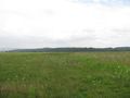
The hash lay on a meadow near Calden.
Participants
Plans
Today I wanted to take the bus.
Expedition
I left home at 13:40, and the transport planner told me an arrival time at Wilhelmsthal one hour later. But there was a tram failure in the city and the regiotram to Espenau got a delay of ten minutes, which was enough to miss the bus there. So I waited nearly one hour for the next one. From Wilhelmsthal I walked on. The last weeks I had two geohashes with already crop on the field and today I wanted only to see the field. To my astonishment there was no field but a meadow. Good luck! The hash was 30 meters away from the field way. No need for a dance. A little bit rain. Some sun. Fun.
Photos

a meadow!

30 meters to hash
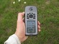
proof

the geohasher
the east

the south
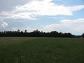
the west
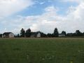
the north

a guest


Achievements
GeorgDerReisende earned the Land geohash achievement
|