Difference between revisions of "2017-08-09 52 13"
imported>CamelCase m (→Expedition) |
imported>CamelCase (→Tracklog) |
||
| Line 34: | Line 34: | ||
== Tracklog == | == Tracklog == | ||
<!-- if your GPS device keeps a log, you may post a link here --> | <!-- if your GPS device keeps a log, you may post a link here --> | ||
| − | [http://www.openstreetmap.org/user/Alpacacase/traces/2474066 OSM] | + | [http://www.openstreetmap.org/user/Alpacacase/traces/2474066 OSM]<br /> |
[[Image:2017-08-09_52_13_CamelCase_1502369129040.jpg]] | [[Image:2017-08-09_52_13_CamelCase_1502369129040.jpg]] | ||
Revision as of 13:16, 10 August 2017
| Wed 9 Aug 2017 in 52,13: 52.8311615, 13.0997580 geohashing.info google osm bing/os kml crox |
Location
In the woods near Oranienburg.
Participants
Expedition
Having arrived at Oranienburg's train station, I headed out in the direction of the hash. Soon I left the town and was following a track surrounded by corn fields. Having crossed a bridge over a highway and passed a few last buildings I finally reached the town's official border and continued following the track which led me into a forest with lots of mosquitoes. Some time later, after having crossed a high-speed road, which went through said forest, my phone's battery started dying, so I grabbed my portable battery charger in order discover that it lacks the capability to charge my phone via a fancy type-c cord. Since I was in the middle of a forest and had no intention to wander aimlessly on its tracks, I used the last amount of charge my phone had to find the next bus stop. I had to go back to that high-speed road, and follow it for two kilometers. I eventually reached the stop and, after waiting for a bit over an hour, a bus arrived to take me back to Oranienburg. I don't think xkcd #1872 is that funny anymore. :p
Tracklog

Photos
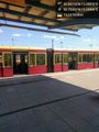
I arrived at Oranienburg station. @52.7538,13.2491
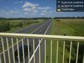
Definitely not Oranienburg anymore. Must have missed the road signs. @52.7674,13.2098
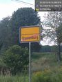
Some lone houses and a lot of corn fields later I am finally leaving the town. @52.7750,13.1984
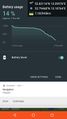
Phone's battery is dying. Since I have no intention to get lost in the woods without a phone, I'm turning back. @52.7947,13.1876
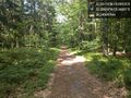
What was ahead of me, when I turned back.

as close as I got
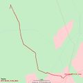
Tracklog


Achievements