Difference between revisions of "2017-08-26 -33 149"
From Geohashing
imported>Ephphatha (Creating expedition page) |
imported>FippeBot m (Location) |
||
| Line 27: | Line 27: | ||
[[Category:Expeditions with photos]] | [[Category:Expeditions with photos]] | ||
[[Category:Coordinates reached]] | [[Category:Coordinates reached]] | ||
| + | {{location|AU|NSW}} | ||
Revision as of 02:54, 16 August 2019
| Sat 26 Aug 2017 in Bathurst: -33.4093047, 149.8031270 geohashing.info google osm bing/os kml crox |
Contents
[hide]Location
Deep within Sunny Corner State Forest, on the western bank of Gulf Stream (not to be confused with the gulf stream).
Attendees
Report
I'd been keeping an occasional eye on the hash map in the hopes the stars would align and I'd get an accessible hash on a weekend I wasn't already busy. Today the stars aligned, and the hash fell in an area that was feasible to reach in the time I had available. The hash was a relatively easy ride down a logging road then a short bit of bushwhacking to get a close as the GPS would register.
Photos
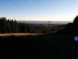
Looking back over the road into the forest.
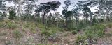
A photosphere taken from the hashpoint.
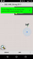
The proof.


