Difference between revisions of "2017-09-18 47 -122"
From Geohashing
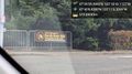
imported>Thomcat ([live picture]Location [http://www.openstreetmap.org/?lat=47.66660640&lon=-122.17829550&zoom=16&layers=B000FTF @47.6666,-122.1783]) |
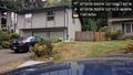
imported>Thomcat ([live picture]Geohasher [http://www.openstreetmap.org/?lat=47.66655350&lon=-122.17831030&zoom=16&layers=B000FTF @47.6666,-122.1783]) |
||
| Line 32: | Line 32: | ||
Image:2017-09-18_47_-122_thomcat_1505774524304.jpg|Location [http://www.openstreetmap.org/?lat=47.66660640&lon=-122.17829550&zoom=16&layers=B000FTF @47.6666,-122.1783] | Image:2017-09-18_47_-122_thomcat_1505774524304.jpg|Location [http://www.openstreetmap.org/?lat=47.66660640&lon=-122.17829550&zoom=16&layers=B000FTF @47.6666,-122.1783] | ||
| + | |||
| + | Image:2017-09-18_47_-122_thomcat_1505774549302.jpg|Geohasher [http://www.openstreetmap.org/?lat=47.66655350&lon=-122.17831030&zoom=16&layers=B000FTF @47.6666,-122.1783] | ||
</gallery> | </gallery> | ||
Revision as of 22:42, 18 September 2017
| Mon 18 Sep 2017 in Seattle: 47.6665554, -122.1783646 geohashing.info google osm bing/os kml crox |
Location
Driveway of a house in south Rose Hill, Kirkland.
Participants
Plans
Stop by after work.
Expedition
Tracklog
Photos
South Rose Hill @47.6691,-122.1851
Location @47.6666,-122.1783

Geohasher @47.6666,-122.1783


Achievements