Difference between revisions of "2017-10-30 49 8"
imported>DODO (→Plans) |
imported>DODO |
||
| Line 33: | Line 33: | ||
== Expedition == | == Expedition == | ||
<!-- how it all turned out. your narrative goes here. --> | <!-- how it all turned out. your narrative goes here. --> | ||
| + | It took a while until I could leave, because little lady came here foe a visit (she's already studiing now). But it was still in the morning. | ||
| + | |||
| + | here shouldn't be much to tell but I visited a little park and found an interesting sculpure and the grave of the former chancelor Helmut Kohl who died this year. The hash was more or less boring on a small path between a house and some garages. GPS located me inside of the garage but as you can see on the pictures I was outside :-) | ||
| + | |||
| + | Ah, before I forgot it, I managed to achieve a tron achievement. | ||
== Tracklog == | == Tracklog == | ||
<!-- if your GPS device keeps a log, you may post a link here --> | <!-- if your GPS device keeps a log, you may post a link here --> | ||
| − | + | [https://www.komoot.de/tour/24657834 5 KM by foot] | |
== Photos == | == Photos == | ||
<!-- Insert pictures between the gallery tags using the following format: | <!-- Insert pictures between the gallery tags using the following format: | ||
Image:2012-##-## ## ## Alpha.jpg | Witty Comment | Image:2012-##-## ## ## Alpha.jpg | Witty Comment | ||
--> | --> | ||
| − | <gallery perrow=" | + | <gallery perrow="6"> |
| + | Image: 2017-10-30 49 8-6.jpg|sculpture | ||
| + | Image: 2017-10-30 49 8-5.jpg|grave of Helmut Kohl | ||
| + | Image: 2017-10-30 49 8-1.png|proof | ||
| + | Image: 2017-10-30 49 8-4.jpg|view to the north | ||
| + | Image: 2017-10-30 49 8-3.jpg|and the south | ||
| + | Image: 2017-10-30 49 8-2.jpg|and the east (hasher in front) view to the west was just a white wall | ||
</gallery> | </gallery> | ||
== Achievements == | == Achievements == | ||
| − | {{ | + | {{land geohash |
| − | + | | latitude = 49 | |
| + | | longitude = 8 | ||
| + | | date = 2017-10-30 | ||
| + | | name = DODO | ||
| + | }} | ||
| − | + | {{Template:Tron | |
| − | + | | latitude = 49 | |
| − | + | | longitude = 8 | |
| + | | date = 2017-10-30 | ||
| + | | name = DODO | ||
| + | | tracklog = https://www.komoot.de/tour/24657834 | ||
| + | | possessive = his | ||
| + | }} | ||
| − | + | {{Walk geohash | |
| − | + | | latitude = 49 | |
| − | + | | longitude = 8 | |
| − | + | | date = 2017-10-30 | |
| − | + | | name = DODO | |
| − | + | | distance = 5 KM | |
| + | }} | ||
| − | |||
| − | |||
[[Category:Expeditions]] | [[Category:Expeditions]] | ||
| − | |||
[[Category:Expeditions with photos]] | [[Category:Expeditions with photos]] | ||
| − | |||
| − | |||
| − | |||
| − | |||
| − | |||
[[Category:Coordinates reached]] | [[Category:Coordinates reached]] | ||
| − | |||
| − | |||
| − | |||
| − | |||
| − | |||
| − | |||
| − | |||
| − | |||
| − | |||
| − | |||
| − | |||
| − | |||
| − | |||
| − | |||
| − | |||
| − | |||
| − | |||
| − | |||
Revision as of 11:04, 30 October 2017
| Mon 30 Oct 2017 in 49,8: 49.3275365, 8.4332619 geohashing.info google osm bing/os kml crox |
Location
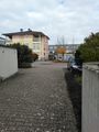
A path in Speyer. Absolutly to close not to go.
Participants
Plans
Walk there in the morning.
Expedition
It took a while until I could leave, because little lady came here foe a visit (she's already studiing now). But it was still in the morning.
here shouldn't be much to tell but I visited a little park and found an interesting sculpure and the grave of the former chancelor Helmut Kohl who died this year. The hash was more or less boring on a small path between a house and some garages. GPS located me inside of the garage but as you can see on the pictures I was outside :-)
Ah, before I forgot it, I managed to achieve a tron achievement.
Tracklog
Photos
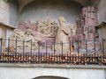
sculpture
grave of Helmut Kohl
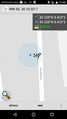
proof
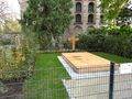
view to the north
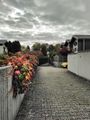
and the south
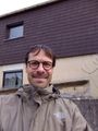
and the east (hasher in front) view to the west was just a white wall


Achievements
DODO earned the Land geohash achievement
|
DODO earned the Tron achievement
|
DODO earned the Walk geohash Achievement
|