Difference between revisions of "2018-04-13 35 -78"
imported>Pedalpusher (added pictures) |
imported>FippeBot m (Location) |
||
| Line 33: | Line 33: | ||
[[Category:Coordinates reached]] | [[Category:Coordinates reached]] | ||
[[Category:Expeditions with photos]] | [[Category:Expeditions with photos]] | ||
| + | {{location|US|NC|FR}} | ||
Latest revision as of 03:00, 7 August 2019
| Fri 13 Apr 2018 in 35,-78: 35.9788698, -78.1891654 geohashing.info google osm bing/os kml crox |
Location
In the woods, NW of Spring Hope, NC
Participants
Expedition
On a road trip to visit my brother in New Bern, NC, I stopped in Maryland Thursday evening to break up the drive. Unfortunately, there were no good hashpoints on the way to MD, but getting ready to finish the drive to NC, I found this hash would only add a half hour to the trip. Looking at the street-view, I didn't see any posted signs, so I wrote out new directions in the hope of adding a new graticule to my list.
Arriving on the road by the hash, I was happy to confirm no posted signs, but the area by the hash that looked like a clear cut forest was very thick and overgrown. Fortunately, the hash looked to be close to the woods on the side which were much more open. Walking toward the hash I found it was right at the edge of the thick area, but it took a bit of a GPS dance to get a close reading.
Success found, I headed back to the road and finished up my drive to my brother's house.
Photos
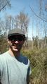
Made it!

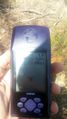
Accuracy.
A success in a new graticule!
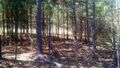
A view of the woods that I walked through to get to the hash, from the hash.
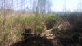
A view of the hash (by the stump on the right) and the clear-cut forest behind that is now overgrown with shrubs.


Ribbons
This user earned the Land geohash achievement
|