Difference between revisions of "2018-05-13 49 8"
imported>DODO |
imported>DODO |
||
| Line 46: | Line 46: | ||
--> | --> | ||
<gallery perrow="5"> | <gallery perrow="5"> | ||
| + | Image:2018-05-13_49_8-10.jpg|still 200 m in ... | ||
| + | Image:2018-05-13_49_8-1.jpg|...this direction | ||
| + | Image:2018-05-13_49_8-2.jpg|view back, bull already out of sight | ||
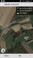
| + | Image:2018-05-13_49_8-11.jpg|proof | ||
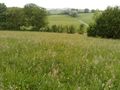
| + | Image:2018-05-13_49_8-3.jpg|view to the west | ||
| + | Image:2018-05-13_49_8-4.jpg|the east (well, I guess I should have gone into the copse) | ||
| + | Image:2018-05-13_49_8-5.jpg|the noth (and a bird fight) | ||
| + | Image:2018-05-13_49_8-6.jpg|and the hasher | ||
| + | Image:2018-05-13_49_8-7.jpg|Here I left my bull (proof of transport) | ||
| + | Image:2018-05-13_49_8-8.jpg|this black dot on my finger is a baby-raptor. I found 3 of them when I had returned to my bull | ||
| + | Image:2018-05-13_49_8-9.jpg|celebration | ||
</gallery> | </gallery> | ||
| Line 51: | Line 62: | ||
{{#vardefine:ribbonwidth|800px}} | {{#vardefine:ribbonwidth|800px}} | ||
<!-- Add any achievement ribbons you earned below, or remove this section --> | <!-- Add any achievement ribbons you earned below, or remove this section --> | ||
| + | {{land geohash | ||
| + | | latitude = 49 | ||
| + | | longitude = 8 | ||
| + | | date = 2018-05-13 | ||
| + | | name = DODO | ||
| + | }} | ||
| − | + | {{Velociraptor geohash | |
| − | + | | latitude = 49 | |
| − | + | | longitude = 8 | |
| + | | date = 2018-05-13 | ||
| + | | name = DODO | ||
| + | }} | ||
| − | + | {{Template:Tron | |
| + | | latitude = 49 | ||
| + | | longitude = 8 | ||
| + | | date = 2018-05-13 | ||
| + | | name = DODO | ||
| + | | possessive = his | ||
| + | }} | ||
| − | |||
| − | |||
| − | |||
| − | |||
| − | |||
| − | |||
| − | |||
| − | |||
[[Category:Expeditions]] | [[Category:Expeditions]] | ||
| − | |||
[[Category:Expeditions with photos]] | [[Category:Expeditions with photos]] | ||
| − | |||
| − | |||
| − | |||
| − | |||
| − | |||
[[Category:Coordinates reached]] | [[Category:Coordinates reached]] | ||
| − | |||
| − | |||
| − | |||
| − | |||
| − | |||
| − | |||
| − | |||
| − | |||
| − | |||
| − | |||
| − | |||
| − | |||
| − | |||
| − | |||
| − | |||
| − | |||
| − | |||
| − | |||
Revision as of 15:09, 13 May 2018
| Sun 13 May 2018 in 49,8: 49.2117904, 8.7919093 geohashing.info google osm bing/os kml crox |
Location
A copse on a grassland near Waldangelloch.
Participants
Plans
Expedition
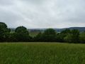
I started my bull ten minutes to eleven. It was quite cold (compared to the 25 + x°C on the last days) and we had a strong wind from the west. Well, I had to go east, so the wind was perfect for me (at least on my way to the hash). I tried to reach a ton achievement, so I found some new paths on my ride to the Kraichgau. At 12:15 I came as close to the hash as my bull can get. Still 200 m to go. Upwards on a hill in waist-high grass. After 100 m I reached a copse and had to walk along. But after a while I found a path through it. Another 100 m to go, and then I came - close enough. OK, there are still 5 m missing, but that is within the uncertainty circle (Ito be honest, I couldn't get closer into a really dense copse). I tried it from the other side but missed the point for 20 m here. Anyway, good enough is good enough.
I returned to my bull. Of course I couldn't stop crossing my way on the way to the hash, but at least the bull doesn't (and hash dancing doesn't count, I think). I returned to Speyer through the Angelbachtal, a nice valley in the Kraichgau. I came very close to my own path at the bridge of Speyer, but took the right side both times, so I didn't cross. For celebrating the hash I took an ice cream and a coffee in Speyer before I returned home.
Tracklog
Photos
still 200 m in ...
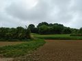
...this direction
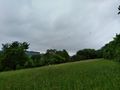
view back, bull already out of sight
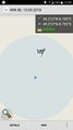
proof
view to the west
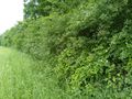
the east (well, I guess I should have gone into the copse)
the noth (and a bird fight)

and the hasher
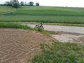
Here I left my bull (proof of transport)
this black dot on my finger is a baby-raptor. I found 3 of them when I had returned to my bull
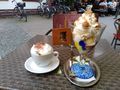
celebration


Achievements
DODO earned the Land geohash achievement
|
DODO earned the Velociraptor Geohash Achievement
|
DODO earned the Tron achievement
|