Difference between revisions of "2018-05-21 50 11"
From Geohashing
imported>Reinhard (mini report) |
imported>Reinhard (→Photos) |
||
| Line 21: | Line 21: | ||
== Photos == | == Photos == | ||
{{gallery|width=200|height=200|lines=1 | {{gallery|width=200|height=200|lines=1 | ||
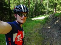
| − | |Image:20180521-50N11E-01.jpg| | + | |Image:20180521-50N11E-01.jpg|Coordinates reached. |
| − | |Image:20180521-50N11E-02.jpg| | + | |Image:20180521-50N11E-02.jpg|I took the bike too far. |
| − | |Image:20180521-50N11E-03.jpg| | + | |Image:20180521-50N11E-03.jpg|At the hashpoint.}} |
[[Category:Expeditions]] | [[Category:Expeditions]] | ||
[[Category:Expeditions with photos]] | [[Category:Expeditions with photos]] | ||
[[Category:Coordinates reached]] | [[Category:Coordinates reached]] | ||
Revision as of 16:21, 25 May 2018
| Mon 21 May 2018 in 50,11: 50.7499123, 11.3766712 geohashing.info google osm bing/os kml crox |
Location
In a forest between the villages Oberhasel, Teichweiden and Mötzelbach near Rudolstadt, Thuringia, Germany.
Participants
Expedition
Cycling there on my way from Erfurt to Jena.
Tracklog
Photos
|


