Difference between revisions of "2018-05-26 35 -81"
From Geohashing
imported>OtherJack ([live picture]Proof [http://www.openstreetmap.org/?lat=35.04138300&lon=-81.02024770&zoom=16&layers=B000FTF @35.0414,-81.0202]) |
imported>Thomcat |
||
| Line 1: | Line 1: | ||
| − | |||
| − | |||
{{meetup graticule | {{meetup graticule | ||
| lat=35 | | lat=35 | ||
| Line 35: | Line 33: | ||
== Achievements == | == Achievements == | ||
| − | [[Category: | + | |
| + | [[Category:Expeditions]] | ||
| + | [[Category:Expeditions with photos]] | ||
| + | [[Category:Coordinates reached]] | ||
Revision as of 16:09, 30 May 2018
| Sat 26 May 2018 in Gastonia: 35.0413542, -81.0203118 geohashing.info google osm bing/os kml crox |
Location
Woods or a park in Tega Cay, near Lake Wylie.
Participants
Plans
Leave 2pm or a little before (by bike), arrive 4pm for Mouseover Day, home by 6:30 or so.
Expedition
- Almost there, eta 4:30pm -- OtherJack (talk) @35.0603,-80.9957 16:19, 26 May 2018 (EDT)
Photos
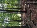
Made it several minutes ago!! Happy mouseover day @35.0414,-81.0203
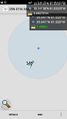
Proof @35.0414,-81.0202

