Difference between revisions of "2018-06-26 51 13"
From Geohashing
imported>Oisín (An expedition message sent via Geohash Droid for Android.) |
imported>Oisín (Expedition) |
||
| Line 1: | Line 1: | ||
| − | |||
| − | |||
| − | |||
| − | |||
| − | |||
| − | |||
| − | |||
| − | |||
{{meetup graticule | {{meetup graticule | ||
| lat=51 | | lat=51 | ||
| Line 19: | Line 11: | ||
== Location == | == Location == | ||
| − | + | The hash is located in Dresden, in the Ostragehege right besides the tramway bridge. | |
| + | |||
| + | Country: Germany; state: Sachsen (Saxony, EU:DE:SN); municipality: Dresden | ||
| + | |||
| + | Weather: 20°C, partially cloudy | ||
== Participants == | == Participants == | ||
| − | |||
| − | |||
| − | + | [[User:Oisín|Oisín]] ([[User talk:Oisín|talk]]) | |
| − | |||
== Expedition == | == Expedition == | ||
| − | |||
| − | == | + | === [[User:Oisín|Oisín]] ([[User talk:Oisín|talk]]) === |
| − | + | I did a small detour on my way home late after work along the river Elbe straigth to the hashpoint near the sporting areas in the Ostragehege. It was a warm evening and there were not many people around, just a few on the soccer pitches and the gymnastic area. After taking a few pictures I continued my way home. | |
| + | |||
== Photos == | == Photos == | ||
<!-- Insert pictures between the gallery tags using the following format: | <!-- Insert pictures between the gallery tags using the following format: | ||
Image:2012-##-## ## ## Alpha.jpg | Witty Comment | Image:2012-##-## ## ## Alpha.jpg | Witty Comment | ||
| + | |||
| + | 2018-06-26_51_13_self.jpg | ||
| + | File:2018-06-26 51 13 bridge.jpg | ||
| + | |||
--> | --> | ||
<gallery perrow="5"> | <gallery perrow="5"> | ||
| + | Image:2018-06-26_51_13_self.jpg | Oisín at the hash point | ||
| + | Image:2018-06-26 51 13 bridge.jpg | Looking north | ||
</gallery> | </gallery> | ||
== Achievements == | == Achievements == | ||
{{#vardefine:ribbonwidth|800px}} | {{#vardefine:ribbonwidth|800px}} | ||
| − | + | {{bicycle geohash | |
| − | + | | latitude = 51 | |
| − | + | | longitude = 13 | |
| − | + | | date = date (2018-06-26) | |
| + | | name = Oisín | ||
| + | | distance = 11 km | ||
| + | }} | ||
| − | |||
| − | |||
| − | |||
| − | |||
| − | |||
| − | |||
| − | |||
| − | |||
| − | |||
[[Category:Expeditions]] | [[Category:Expeditions]] | ||
| − | |||
[[Category:Expeditions with photos]] | [[Category:Expeditions with photos]] | ||
| − | |||
| − | |||
| − | |||
| − | |||
| − | |||
[[Category:Coordinates reached]] | [[Category:Coordinates reached]] | ||
| − | |||
| − | |||
| − | |||
| − | |||
| − | |||
| − | |||
| − | |||
| − | |||
| − | |||
| − | |||
| − | |||
| − | |||
| − | |||
| − | |||
| − | |||
| − | |||
| − | |||
| − | |||
Revision as of 06:09, 27 June 2018
| Tue 26 Jun 2018 in 51,13: 51.0655139, 13.7164614 geohashing.info google osm bing/os kml crox |
Location
The hash is located in Dresden, in the Ostragehege right besides the tramway bridge.
Country: Germany; state: Sachsen (Saxony, EU:DE:SN); municipality: Dresden
Weather: 20°C, partially cloudy
Participants
Expedition
Oisín (talk)
I did a small detour on my way home late after work along the river Elbe straigth to the hashpoint near the sporting areas in the Ostragehege. It was a warm evening and there were not many people around, just a few on the soccer pitches and the gymnastic area. After taking a few pictures I continued my way home.
Photos
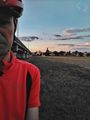
Oisín at the hash point
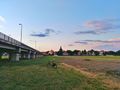
Looking north


Achievements
Oisín earned the Bicycle geohash achievement
|