Difference between revisions of "2018-08-26 50 9"
imported>GeorgDerReisende (planning expedition for Obergrenzebach) |
imported>GeorgDerReisende (expedition report for Frielendorf-Obergrenzebach) |
||
| Line 1: | Line 1: | ||
| − | |||
| − | |||
| − | |||
| − | |||
| − | |||
| − | |||
| − | |||
| − | |||
| − | |||
| − | |||
{{meetup graticule | {{meetup graticule | ||
| lat=50 | | lat=50 | ||
| Line 36: | Line 26: | ||
== Expedition == | == Expedition == | ||
<!-- how it all turned out. your narrative goes here. --> | <!-- how it all turned out. your narrative goes here. --> | ||
| + | |||
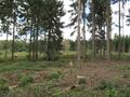
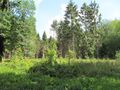
| + | The journey happened as planned. I arrived at Obergrenzebach at 12:15. Then I walked to the hash. The first view at the crossing of the forest ways showed a high moor. But I arrived at the hash at 13:20 and there was a clearing. I danced around in the forest. The shortest match was 4 meter. Then I waited until 14:15 for another geohashers to arrive, but nobody did. | ||
== Tracklog == | == Tracklog == | ||
| Line 45: | Line 37: | ||
--> | --> | ||
<gallery perrow="5"> | <gallery perrow="5"> | ||
| + | Image:2018-08-26 50 9 GeorgDerReisende 0464.jpg | view from Obergrenzebach to the mount of hash | ||
| + | Image:2018-08-26 50 9 GeorgDerReisende 0494.jpg | some sort of moor in front of the hash | ||
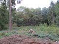
| + | Image:2018-08-26 50 9 GeorgDerReisende 0495.jpg | the area of hash | ||
| + | Image:2018-08-26 50 9 GeorgDerReisende 0496.jpg | around here | ||
| + | Image:2018-08-26 50 9 GeorgDerReisende 0497.jpg | proof | ||
| + | Image:2018-08-26 50 9 GeorgDerReisende 0498.jpg | view to the north | ||
| + | Image:2018-08-26 50 9 GeorgDerReisende 0499.jpg | the east | ||
| + | Image:2018-08-26 50 9 GeorgDerReisende 0500.jpg | the south | ||
| + | Image:2018-08-26 50 9 GeorgDerReisende 0501.jpg | the west | ||
| + | Image:2018-08-26 50 9 GeorgDerReisende 0502.jpg | the geohasher | ||
| + | Image:2018-08-26 50 9 GeorgDerReisende 0508.jpg | the nearby forest way to the north | ||
| + | Image:2018-08-26 50 9 GeorgDerReisende 0509.jpg | the way to the south | ||
| + | Image:2018-08-26 50 9 GeorgDerReisende 0513.jpg | no view to the hash from the forest way | ||
</gallery> | </gallery> | ||
| Line 50: | Line 55: | ||
{{#vardefine:ribbonwidth|800px}} | {{#vardefine:ribbonwidth|800px}} | ||
<!-- Add any achievement ribbons you earned below, or remove this section --> | <!-- Add any achievement ribbons you earned below, or remove this section --> | ||
| + | |||
| + | {{land geohash | latitude = 50 | longitude = 9 | date = 2018-08-26 | name = GeorgDerReisende }} | ||
<!-- =============== USEFUL CATEGORIES FOLLOW ================ | <!-- =============== USEFUL CATEGORIES FOLLOW ================ | ||
Delete the next line ONLY if you have chosen the appropriate categories below. If you are unsure, don't worry. People will read your report and help you with the classification. --> | Delete the next line ONLY if you have chosen the appropriate categories below. If you are unsure, don't worry. People will read your report and help you with the classification. --> | ||
| − | |||
| − | + | [[Category:Expeditions]] | |
| − | + | [[Category:Expeditions with photos]] | |
| − | |||
| − | [[Category: | ||
| − | |||
| − | |||
| − | |||
| − | |||
| − | |||
| − | |||
| − | |||
| − | |||
| − | |||
| − | |||
| − | |||
| − | |||
[[Category:Coordinates reached]] | [[Category:Coordinates reached]] | ||
| − | |||
| − | |||
| − | |||
| − | |||
| − | |||
| − | |||
| − | |||
| − | |||
| − | |||
| − | |||
| − | |||
| − | |||
| − | |||
| − | |||
| − | |||
| − | |||
| − | |||
| − | |||
Revision as of 08:50, 27 August 2018
| Sun 26 Aug 2018 in 50,9: 50.9215015, 9.3355937 geohashing.info google osm bing/os kml crox |
Location
The hash lies in the forest between Obergrenzebach in the west, Großropperhausen in the northeast and Seigertshausen in the southeast. Looks like a meadow.
Participants
Plans
Leaving home at 9:20. Want to take the tram 3 to Wilhelmshöhe train station, the train RE 30 to Treysa, the bus 470 to Ziegenhain, Alleeplatz and dial-a-ride transit 473 to Obergrenzebach. Then there is a three kilometer walk. Want to be there at 14:00. I cannot wait there, because I need to get another dial-a-ride transit at Obergrenzebach for the journey back.
Expedition
The journey happened as planned. I arrived at Obergrenzebach at 12:15. Then I walked to the hash. The first view at the crossing of the forest ways showed a high moor. But I arrived at the hash at 13:20 and there was a clearing. I danced around in the forest. The shortest match was 4 meter. Then I waited until 14:15 for another geohashers to arrive, but nobody did.
Tracklog
Photos
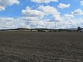
view from Obergrenzebach to the mount of hash
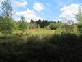
some sort of moor in front of the hash
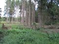
the area of hash
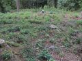
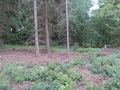
around here
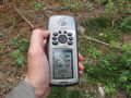
proof
view to the north
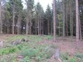
the east
the south
the west
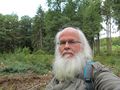
the geohasher
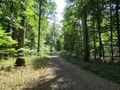
the nearby forest way to the north
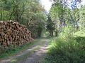
the way to the south
no view to the hash from the forest way


Achievements
GeorgDerReisende earned the Land geohash achievement
|